Monday 26 March 2012

Pecos, Texas

Leaving Van Horn, we drove along the wide open spaces of  I20 to Pecos (pronounced Peycuss) a small, dusty West Texas town amid working oil and natural gas fields.

Once set up at the RV park we visited the West of Pecos Museum, it was originally the Orient Hotel and once “the finest from Fort Worth to El Paso”.   The building is constructed of Pecos Valley Red Sandstone the saloon opened in 1896 and the hotel in 1907.   

There is a replica of the old saloon, along with brass plates on the floor showing where William Earheart and John Denson were shot and killed by Barney Riggs.  One of the brass plates is to the right of this photograph.

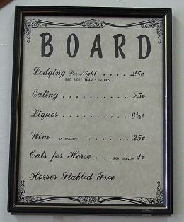
Since 1907 hotel prices have increased somewhat and I don’t know what sort of wine you’d get these days for 25 cents a gallon!

The museum also has exhibits of towns that no either no longer exist or have just a few people living in them.  One of which, Toyah, we passed on I20, once home to 5,000 people with 2 schools, several churches, 2 banks, over 17 saloons, 2 livery stables, an ice house and goodness knows what else, it’s now home to only 115 people.  A quilt in the museum depicts what is left of the town.

Outside the museum is a replica of the house of Judge Roy Bean, famously known as the Law West of the Pecos.

Around the corner is the grave of Clay Allison, who according to legend, was a Confederate Spy and when captured escaped by slipping his unusually small hands through the manacles.  He was known as the “Gentleman” gunfighter because it was said he never killed a man that didn’t need killing!

Cantaloupes grown in Pecos are famous for their flavour, I believe the soil in the area makes them particularly sweet.   Unfortunately we didn’t get to try them as the season doesn’t start until the summer.

Pecos is also the home of the world’s first rodeo and a rodeo is held every year, usually during June.

Have fun, we are!

Saturday 24 March 2012

Van Horn, Texas

Earlier this week we left Deming and stopped in El Paso to get our annual Texas Vehicle Inspection Certificates before continuing to Van Horn, which is a really small town on I10.
 
Main Street

Along the way we lost an hour as Van Horn is on central time, which was kinda nice as it stayed light around 8.30 p.m.

We had dinner at Chuy’s a Mexican/American restaurant on Broadway which has earned a place in the Madden Haul of Fame.  John Madden is an American football broadcaster who won’t fly, so he spends a lot of time criss-crossing the country by bus and this is one of his favourite restaurants.   I had hoped to try the tequila lime pie, but sadly they didn’t have any, oh well maybe next time.  

Next morning, because it was so late we actually saw the sunrise over the mountains from our spot at the KOA and yes it really was that colour, I haven’t been playing with photoshop.

We’ve only ever stayed overnight in Van Horn, but next time we pass this way I wouldn’t mind staying a little longer and visiting the historic El Capitan hotel, taking Red Ranch Tour and maybe finding the Lobo Valley petroglyphs. 

Have fun, we are!

Monday 19 March 2012

Dusty Day in Deming

Saturday was hot and sunny with a strong breeze, today was overcast and very, very, very windy.

Yesterday as we travelled along Highway 180 on our way back from Silver City we watched a dust storm swirling across the desert,

and dust devils climbing high into the sky.

Today that stretch of highway was closed for a large part of the day due to blowing dust and poor visibility, I10 was also closed for the same reason for part of the day.

Tomorrow in Deming the forecast is for much cooler temperatures and rain, while in Silver City they are expecting snow!

Who would-a-thunk that on Saturday when we were wandering round in shorts and t-shirts!

Have fun, we are!

The Kneeling Nun

Spanish explorers thought the rock formation high above the Santa Rita copper mine resembled a veiled woman although I can’t actually see it myself.

Legend says that a nun, forsaking her vows, fell in love with a soldier and was cast out from her religious order.   At the base of the bluff she built a stone altar where while praying for forgiveness of her sins she was turned into stone.

Because of the legend Spanish explorers refused to camp near the rock, even though it was an excellent vantage point.   Explorers also thought that the fabled Seven Cities of Cibola lay buried somewhere in the region 

We took our photographs from the Chino Mines observation point on Highway 152 which is approximately 20 miles away. 


Have fun, we are!

City of Rocks State Park, New Mexico

At something cold and dark o’clock on Friday morning DB threw me out of bed and before I knew it we were watching Tucson disappear in the rear view mirror.

After an uneventful drive on a sunny warm day we arrived in Deming, New Mexico our home for the next few days.

Yesterday, Saturday, we drove out to City of Rocks State Park at mile post 3 on highway 61 just north of Deming.   City of Rocks was formed over 34 million years ago in a huge volcanic eruption 1,000 times greater than the eruption of Mount St Helens in 1980.
  
The rock formations are so unique that there are only 6 other places in the world where they are known to exist.

Mimbres Indians once roamed the area, Chiricahua and Warm Springs Apache traditional homelands are also nearby. 

In the early 16th century Spanish explorers and settlers arrived and mule trains loaded with copper from the nearby Santa Rita mines passed close by on their way to Chihuahua, Mexico.

After the Mexican War ended in 1848, the Mormon Battalion blazed a trail through the area linking New Mexico and Arizona to the eastern US.

City of Rocks state park was formed in the early 1950’s and was also the first New Mexico state park to receive an observatory, star parties take place at the park during the year.

DB decided to have a snooze in BT while I spent a couple of hours slithering through the rocks and taking tons of photographs.

Have fun, we are!

Wednesday 14 March 2012

WA:K Pow Wow

Last weekend was the 30th Annual WA:K Pow Wow, lasting over two days it is Tucson’s largest gathering of American Indians.

There were craft stalls with some absolutely beautiful jewellery, and food stalls with burgers, tacos and frybread

Indian Frybread
Zillions of calories but totally delicious, reminds me a bit of Yorkshire pudding!

The dance arena was blessed and while photographs were allowed, the Master of Ceremonies advised when they weren’t.

Junior Dance

Inter Tribal Dance


Jingle Dance

Fancy Shawl Dance

We enjoyed our visit to the Pow Wow especially the tasty frybread!

Have fun, we are!

Tuesday 13 March 2012

Sabino Canyon, again

On a much cooler day we took our second trip to Sabino Canyon, taking the tram to the top we walked about 4 miles along the road back to the visitor centre.  It’s a pretty road and follows the creek all the way.

Interesting bush.

Not sure what these berries were.

Further down we came to a pretty waterfall

We enjoyed a picnic lunch on a beach under the cottonwoods.

Not at all sure what this bird was but it was very cute, sadly it turned round as I  took the photograph. 

As they have more protection from the cold and frost during the winter months more saguaros grow on the sunny west side of the canyon than the cooler east side.
Have fun, we are!

Thursday 8 March 2012

Welcome

Welcome to our new follower, Encourage One Another, we hope you enjoy following us on our travels.

Have fun, we are!

Sabino Canyon – Phone Line Trail

Surrounded by the Pusch Ridge Wilderness, Sabino Canyon lies on the edge of Tucson.   We rode the tram to the top.

and then hiked up the short, steep switchbacks to join the Phoneline Trail.

The Phoneline Trail was built in the early 1900’s as part of a dam project that was never built, a few rusted poles are still visible on sections of the trail.

Once we reached the top of the switchbacks the trail sort of levelled out but was still sandy and rocky, the wildflowers are just starting to bloom.


 The views from the trail are absolutely spectacular.

Looking back into Tucson.

More spectacular views.


From tram stop 9 to the car park the trail is about 5 miles long and although classed as moderate felt pretty strenuous to me!   That's probably because the day we did the hike it turned out to be sunny and very, very hot, far too hot for me, although DB wasn't nearly as bothered by heat.   By the time we reached the car park I was shattered and headed straight to the pool for a refreshing cool down when we got back to Rincon.

Would we do it again?  Yes, probably, but I would start much earlier (I don’t like getting up early) and probably walk up from the car park rather than down from the tram.

Have fun, we are!

Return to San Xavier Del Bac

It’s a couple of years since we last visited San Xavier Del Bac and it’s the first time I think we’ve ever seen it without any scaffolding.

It is a truly beautiful place.

Each time we visit we find out different interesting facts, for instance during major repairs started by Bishop Granjon in 1905 what is now a plaza area (below) was actually designed by the forward looking Bishop to be a parking lot for up to 12 cars.

The plaza in front of the mission was meant to be in the centre of town, but the city of Tucson was built further north.

High up in the decorative stonework

on the left side of the entrance is a cat

On the right hand side is a mouse

The story goes that if the cat ever gets the mouse then the mission will fall.

We had another great visit to San Xavier and enjoyed some delicious Indian Frybread before we left.

Have fun, we are!