Friday 30 January 2015

Moving on

It was time to leave Raton, so on yet another sunny, but chilly morning, we joined I25.   When we left it was 43F and windy, but with the wind behind us most of the way, it practically blew us south.
 
Amazing what a difference a following wind makes to fuel economy!   There was snow on the mountains around Cimarron, but by the time we reached Santa Fe, although it was still cold, the snow had disappeared.
 
We arrived in Bernalillo just after lunch and it was nice to set up in warm sunshine.   I think we left Colorado City and Raton just in time as the forecasts we heard were for very cold weather and snow. 

We saw this cute café sign in Bernalillo.
 
It was lovely to be in warm sunshine again, we took a trip on the New Mexico Rail Runner (great way to travel) to Santa Fe.   Santa Fe is spectacular, I think it’s a place you either fall in love with or wonder why people rave about it.   In case you have noticed, we’re in the first category.
 
St. Francis of Assisi Dancing on Water, this statue by the cathedral is so happy, it can’t help but you smile.

Santa Fe

One of our favourite things to do in Santa Fe, get a coffee and people watch on the plaza.
 
After a few days and a forecast for good weather, we decided we’d head off across I40 via Grants, NM and Holbrook, AZ to Williams, AZ.    Last year our Grand Canyon hiking plans vanished as we arrived in Williams the day the Government shutdown closed all the National Parks.    I know we’ve been to the Grand Canyon quite a few times, but it’s one of our all-time favourite places.

We had great views of Mount Taylor at our overnight stop in Grants.
 
A couple of days later we rolled into the Grand Canyon Railway RV Park, in Williams.
 
Have fun, we are!

Thursday 29 January 2015

Mesas, Volanoes, Thunderstorms and Snow!

Highway 73 took us from Raton, onto the wide open grasslands of windswept Johnson Mesa.   At over 8,000 ft on a beautifully sunny, clear, day we could see for miles.
 
Once we hit the top of the mesa it was absolutely deserted, 

all we saw were some pronghorn, at least I think they were pronghorn, and in the distance we could see some working cowboys.

We stopped at the historic Johnson Mesa Church.   St John’s Methodist Episcopal Church was completed in the 1897 it’s on the State of New Mexico Cultural Register.   The church was locked so we couldn’t look inside.

The cemetery is right across the road.   It’s a very lonely place, and we wondered how far people have to travel to attend church?
 
Dropping down from the mesa we drove into the tiny village of Folsom which, according to the sign, has a population of 77.   The village is named after Francis Folsom, bride-to-be of President Grover Cleveland. When she stepped from the train to explore the little town, the townsfolk were smitten by her charms and changed the name from Rag Town to Folsom in her honour.

The main road in the village of Folsom.
 
Folsom is probably most well known as the home of the discovery of the Folsom Point.   After a disastrous flood in 1908, a cowboy called George McJunkin discovered a cache of fossilized bison bones and realised that the bones weren’t those of modern bison.   The spear points found in the skeletons became known as the Folsom Points.
 
There is a small museum in Folsom and I was looking forward to looking around it, but, unfortunately for me it was only open by appointment.   Oh well, I suppose that is what you get when you’re travelling out of the main season.   Maybe we’ll get chance to visit some other time.

Folsom Museum
 
Our next stop was the Capulin Volcano National Monument.   The National Monument preserves a cinder cone that came into being about 60,000 years ago.
After watching the informational film we drove the narrow 2 mile access road to the top.
 
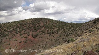
There were some great views across the plains, but we could see some black clouds approaching, although they looked as though they’d miss us.   So we set off along the circular path around the cone.

It was interesting to find out that what we thought were mountains were actually volcanic cinder cones, shield volcanoes, tuff rings and volcanic domes and what looked like flat topped mesas were actually ancient lava flows.

We could also see what looked like rocky ridges, but were in actual fact pressure ridges.   They are caused by hot lava flowing beneath a surface that has already cooled and hardened, fascinating isn’t it?
 
As we followed the path up the side of the cone, the storm we’d thought was quite far away was suddenly closer, and we could hear the thunder and see the lightening. Oops!   Hiking the highest point for miles around in a thunderstorm isn’t the best place to be, so we abandoned our walk and headed back to the truck.
 
The temperature dropped and it was quite fascinating to watch the storm as it got ever closer.

Driving back down we passed the ranger on his way to close the trail.   Before we left the park it was pouring with rain, and before we got to our planned lunch stop at Capulin Country store it was snowing!
 
Sadly, the store no longer has a restaurant, so lunch consisted of coffee and a chocolate bar.    Mind you the store does have some really rather nice things, but I resisted temptation and we followed highway 64 back to Raton.
 
On the way the snow turned to rain and we were treated to a spectacular lightening show.  
 
Have fun, we are!

Wednesday 28 January 2015

Cimarron & Eagle Nest, New Mexico

Heading for Cimarron, we took I25 south then at exit 446 we joined highway 64, on a chilly, grey morning it seemed a very long desolate drive to Cimarron. 
 
Luckily as we arrived in Cimarron the clouds parted and the sun came out.

After a chat with the friendly lady in the visitor centre, we decided we’d drive up Cimarron Canyon before exploring the town.   It turned out to be a good decision as it’s a lovely drive.

The easternmost range of the Sangre De Cristo Mountains, the Cimarron Mountains are the boundary between the Great Plains and the Rocky Mountains.

The Cimarron River cuts through the igneous rock known as sill to produce the amazing cliffs of the Palisades Sill.


Clear Creek was a very pretty spot.
 
We’d originally decided to turnaround at Ute Park, but the drive was so pretty we decided we’d carry on to Eagle Nest.  We were glad we did, it’s a lovely spot.
 
Eagle Nest was the place where members of several Indian tribes were said to have come to collect eagle feathers.
 
Prior to 1919 Charles Springer acquired land and built a dam for irrigation. The dam has a capacity of 78,000 acre feet and provides irrigation for lots of farms in Eastern New Mexico.  

We were tempted to carry on to Red River, but as time was getting on we retraced our steps back to Cimarron.
 
At an elevation of 6,427 ft Cimarron is on the Mountain Branch of the Santa Fe Trail and was settled in 1844.   In 1857 it became the headquarters of the famous Maxwell Land Grant that covered almost 2,000,000 million acres and was also home to Lucien B Maxwell.   From 1862 to 1876 an agency for Utes and Jicarilla Apache was also located in Cimarron.
 
We stopped at the old fashioned coffee bar in the Cimarron Art Gallery for coffee and enjoyed at chat with the lady in the store.

Our next stop was the Aztec Grist Mill.   Construction of the mill by Lucien B Maxwell started in 1860 and was finished in 1864 at a cost of $48,000.00.

The mill was capable of grinding 15,000 lbs of wheat a day, producing 44 barrels of flour.  In 1869 the miller, Isaah Rinehart estimated that the mill was making a profit of over $24,000.00.
 
Our final stop was at the historic St James Hotel. 

Many famous and infamous people including, Jesse James, Bat Masterson and Zane Grey have stayed in the hotel over the years.   If only the walls could talk!

Original room tags.

The lobby area.
 
Cimarron is a long way from anywhere, but would be a nice place to stay for a few days, hopefully we’ll be back to explore some more.
 
Have fun, we are!

Raton, New Mexico

It was mild, although a little on the hazy side, the day we left Colorado City.   Our destination was Raton, New Mexico where we’d decided to stay a few days.   When we arrived it was nice and sunny and our site had a view of the mountains, so after getting set up, we enjoyed a coffee in the sunshine.
 
The next morning, as it was still nice and sunny we had a session of serious rig cleaning, inside and out, by lunchtime we’d finished and decided to drive into Raton and explore.   Naturally, our first stop was a coffee shop we found one called Enchanted Grounds, a nice friendly place with decent coffee and hot chocolate.   Unfortunately, by the time we came out a thunderstorm had rolled in, so as it’s no fun exploring in that sort of weather, we turned around and went back.
 
Although it was still overcast and chilly, it wasn’t raining, so the next morning off we went.   Our first stop was the museum, it’s a very interesting place; we learnt a lot about the history of the town and surrounding area, including the fact that there is enough coal around here to last for 300 years, but at present it’s uneconomical to mine it.
 
Sadly, we didn’t get to see the Shuler Theatre as it was closed.

After lunch in the coffee shop, we continued our walk around the historic district.
 
This building was once a department store.
 
The decoration on this building is beautiful.

The train station is still in use, the lady in the coffee shop told us that not long ago two retired English school teachers arrived on the train and were travelling the US on Amtrak.   What a great way to take a trip.

I think this building was once a hotel.
 
We didn’t linger long as it became very windy and much colder.
 
Have fun, we are!

Tuesday 27 January 2015

Scenic Drive – The Highway of Legends

Our second scenic drive took us along Highway 12, The Highway of Legends.  Again we drove south on I25 and took exit 14.   It was the wrong exit, we should probably have taken 13B, but no matter, we found Highway 12.
 
From what we’d read in the Colorado guide, we expected it to be much more remote, but there were little towns and villages all the way along.
 
We stopped for a while at a pretty overlook unfortunately I’ve forgotten the name of the lake.   Yes, I know, if I kept the blog more up-to-date…

As we drove up Cuchara Pass, at 9,995 ft this is the highest point on the road.
 
We could’ve taken this road back to the interstate, but neither of us fancied 35 miles of dirt road to get there.

As we drove down the other side of the pass, we had some lovely autumn views and colours.
 
La Veta, the end of the drive, was co-founded by frontier trader John Francisco in 1862, and is just as you would expect an old western town to be.

The Denver & Rio Grande railroad laid tracks here in 1876 and kept on heading west over 9,300ft La Veta Pass, making it the highest rail crossing at the time. Although the train still stops, for about 1½ hours, I think we were told, you can no longer buy a ticket and board the train; in fact the ticket office is the town hall.
 
We had hoped to visit the Francisco Fort Museum, but it had closed for the season.
 
This is the Doris Bristol Tracey Memorial.

Doris Tracey, from La Veta, was awarded the Congressional Gold Medal for her service in the Women Air Service Pilots (WASP) during World War II.   WASP’s flew test flights, ferried planes and flew target aircraft while servicemen trained with live ammunition.   These brave women freed up men to fly combat missions and paved the way for modern day female combat pilots.  The Congressional Gold Medal is the highest civilian medal bestowed by Congress. 

After a look around the town and enjoying coffee and a cookie, we always manage to find a coffee shop; and a stop at the supermarket in Walsenburg we headed back to Colorado City.
 
Have fun, we are!

Scenic Drive – The Frontier Pathway

Although the days were still mostly warm and sunny, we’d noticed a definite chill in the air on our early morning trips to the showers, but then again it was October and we were in Colorado.
 
There were a couple of scenic drives we wanted to do, the first of which took us into Westcliffe, along highway 69, The Frontier Pathway.   Taking I25 south at exit 52, we literally followed the road.   On our left the snow-capped Sangre De Cristo Mountains made for spectacular views.
 
At one point something dashed across the road in front of us, although I couldn’t see it properly, it seemed to be quite small and had a black and white stripy nose.   We think it might’ve been an American badger as they’re much smaller than English badgers.
 
Several interesting looking roads disappeared towards the mountains, the signs read Mosca and Great Sand Dunes National Park, not on our itinerary today, but who knows, maybe another time.
 
Grazing buffalo along one section of road looked very photogenic, we stopped, well away from them I hasten to point out, took some photographs and drove on into Westcliffe.
 
I think this one had its eye on us.

After a nice lunch at the Ranchers Roost Café and a quick stop at the bakery for a blueberry muffin, we once more drove back over the mountains to Colorado City.
 
As we were driving today, I forget where, we passed a hardware store, this sign made us smile,
 
it’s definitely not something you’d see outside a hardware store at home!
 
Have fun, we are!

Sunday 25 January 2015

Riding the rails - Royal Gorge Railroad

Cañon City is about equal driving distance from Colorado Springs and Colorado City, so on a sunny, somewhat warmer morning set off from Colorado City to ride the Royal Gorge Railroad.
 
We’d already bought our tickets so all we had to do was pick them up, we drove north on I25 and took US 50 west.   As we drove, we joined CO 115 and crossed wide open prairie, in the distance Pike’s Peak as it rose sharply into the clear blue sky.
 
After picking up our tickets at the station,
 
DB got some coffee, found a bench and sat in the sun, while I had a look in the store.

I bought a couple of things, one of which was a book (well worth reading) about the life of Dr Susan Anderson, known as Doc Susie, who spent some time in Cripple Creek.   We were told, I forget by whom, that the TV show Dr Quinn, Medicine Woman, was based on her life.

Our train boarded at noon, we’d booked seats in the Vista Dome, and had excellent views.   There was a nice lunch menu, but as we weren’t particularly hungry, we just had coffee and raspberry iced tea.

We were right at the front of this carriage.
 
Our train left on time and slowly made its way into the Arkansas River Gorge. At times the gorge is so narrow that you feel you can reach out and touch the rock walls on both sides, of course you can’t and I wouldn’t recommend trying!


In places you can still see remnants of the old wooden pipeline that used to provide water to the town.
 
I think actually being under the bridge makes you realise just how deep the gorge really is. 
 
It was a nice trip, on yet another great day.
 
Have fun, we are!