On the day we visited volunteers were dressed in period costume as part of a living
history day at the San Juan Bautista State Park.
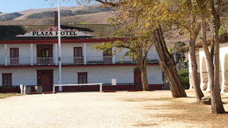
Originally,
what is now the Plaza Hotel, was a one-story adobe barracks and two-story guard
house for the soldiers protecting the mission.
In 1835 the building became a home and general store for the Anzar
family.
It was then sold to an Italian
immigrant, Angelo Zanetta who added the second story and opened the Plaza Hotel
in 1859. The hotel became famous for
its excellent cuisine and liquors.

By the
1860’s San Juan Bautista was a stop for 7 stagecoach lines and when the Idria
Quicksilver mine opened south east of town, even more people stopped at the
hotel.
A
reconstruction of what the dining room would’ve been like, you could get ham
and eggs for 40c and a coffee for 10c.

If you
were a traveller in the mid 1800’s it would take you about 58 hours to travel
the 366 miles from LA to San Juan Bautista, at an average speed of 6.8 miles an
hour and cost $20.00.
Well
furnished rooms were available to travellers, but single travellers shared a
room and sometimes total strangers shared a bed! Not something that would ever even be considered
now, thank goodness.

The
Castro/Breen adobe is an example of eastern and western building methods
produced in Montery and formed the Monterey Colonial Architectural style.
The adobe served as headquarters and
residence of José Antonio Castro, Commandant General of Alta California and
later as home to Donner Party survivors
Patrick Breen and family.
One of the
demonstrations was cooking in a ‘horno’’ oven, it took 3 hours for the horno to
get hot enough to put food in. Thank
goodness for microwaves, I’m really glad I don’t have to cook like that every
day!


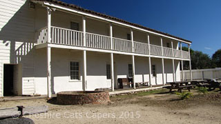
Unmarried
mission women once lived in a dormitory on this site, in 1835 the enlarged
building became the headquarters for General Jose Castro’s cavalrymen.

The
building was later purchased by hotel owner Angelo Zanetta and used to store
hay. He and his partner hoped to sell
the building as the San Benito County Courthouse, the ground floor contained
offices and the first floor was one long open room.
After
Hollister became the county seat, Zanetta added a dining room and kitchen for
his family home and the upstairs was used for town meetings and balls.

Just
across the road from the plaza hotel is a small settlers cabin and what was
possibly the first log cabin in California.
It was moved from its original location on Mission Ventura Ranch.

Once we’d
finished looking round the state park, we walked through town,

we had
coffee and lovely apple cinnamon turnovers in the bakery

I loved
this handbag in one of the store windows.

San Jaun
Bautista is a lovely little town and we really enjoyed our visit.
Have fun,
we are!


