Sunday 24 June 2012

Thank you!

Thank you to Susan over at  Travel Bug http://travelbug-susan.blogspot.co.uk/ who has very kindly nominated me for The Versatile Blogger Award.

Versatile Blogger Award Rules

  • Thank the person who gave you this award. That’s common courtesy.   Done

  • Include a link to their blog. That’s also common courtesy.   Done

  • Next, select 5 blogs you enjoy/follow regularly.   Done

  • 1000 Miles on My Own Two Feet
    http://1000milesonmyowntwofeet.blogspot.co.uk/

    Lens Travels, Living Our Dreams!

    Life on the Open Road
    The continuing adventures of a Full Time RVer

    Brits on Tour (Back Home)

    Rick & Paulette's RV Travels
    http://rickpaulettervjournal.blogspot.co.uk/

    Nominate those 5 bloggers for the Versatile Blogger Award.   Done

  • Finally, mention a few random things about yourself.

  • 1.   I like early mornings, but don't like getting up.

    2.   I can read a map and 99.99% of the time I get it right.

    3.   I must be an optimist as I always expect English summers to be gorgeous hot sunny days with long warm evenings and a few rainy days thrown in to keep everywhere lush and green, whereas it's usually the opposite way round.

    4.   I love to read and although my Kindle is fabulous there is nothing like opening a brand new book.

    5.   One day DB and I will manage to get a permit and do the Grand Canyon rim-to-rim hike.

    That's all for now
    Have fun, we are!
    

    Monday 11 June 2012

    A sunny afternoon

    On a gorgeous sunny afternoon we took a stroll along the towpath, the wildflowers were simply gorgeous.

    Cowslips
    Red Campion

    We had this view from our canal side seat before we turned and headed back.

    Blossom covered hawthorn trees line sections of the canal.

    Cow parsley and hawthorn creep through the gate.

    We had a lovely stroll before heading off to the pub for a couple of beers.

    Sadly since then the weather has rapidly deteriorated, we’ve had grey skies, wind and torrential rain, hopefully summer will come back soon, please!

    Have fun, we are!

    Pima County Fair

    Before we came home at the end of April (I realise it’s now June, but unfortunately events overtook my blog updates) a friend and I headed off to Pima County Fair.   DB declined preferring his sun lounger under the awning.

    We went before it got too hot and too crowded, we had a great time checking out exhibits.   I know two little boys who would’ve spent hours looking at these old John Deere tractors.


    And imagine the fun they’d have ‘bullriding’.

    A prize winning quilt in the craft section,

    Some neat trucks
    not to mention eating Indian Frybread and carousels.

    It was a tough afternoon, but someone had to do it!

     
    Have fun, we are!

    Lake Valley

    Not far from Hillsboro lies the town of Lake Valley which was founded in 1878.   Situated in an area of intermittent spring fed lakes, one was named Silver Lake, not for the silver subsequently found in the area but for the sparkle and clarity of the water.

    The original townsite was moved after the creek overflowed and moved again when the Bridal Chamber Mine was discovered.  The mine contained a blanket of silver ore reputed to be 10 to 20 feet thick.   At its peak the town had a population of 1,000 people but as with so many silver mining towns when silver was devalued in the 1890’s the town died and most people moved away.

    I think this is an old Plymouth?

    The mine entrance and the remains of the old railroad station. 

    In 1895 a fire in the saloon building owned by William Cotton rampaged through the town, as most of the buildings were built of decade old tinder dry milled lumber, nearly all the town especially the commercial district was soon reduced to ashes.   It was thought to be arson and a man named Abernathy was jailed.

    An old photograph of the town.

    This was once the busy commercial district. 

    Foundations, bits of glass and tins are all that line the road, with the exception of a huge safe that was blown up into the air and remains where it landed.

    The town is now owned by the BLM, although the mines and some of the houses are still privately owned, in fact one of the house was lived in until the owner died in the 1980’s.   A museum in the old school house which also doubled as a community hall is interesting and a walking tour guides you around the site.   We spent some time chatting with the knowledgeable caretakers who told us things not to miss.

    Inside the school house. 

    Despite the day being hot and sunny a gusty wind whistled around the buildings, lifting corners on the corrugated iron roofs, sending dust devils swirling through the town, the old Conoco sign swinging creakily back and forth really perfecting the ghost town atmosphere.

    It’s a really interesting place to visit, there is no admission charge, but donations are appreciated.

    Have fun, we are!

    More Ghost Towns

    Another road trip to find a couple more semi-ghost towns, Hillsboro and Kingston, this time we managed to find them both.
     
    Our first stop was Kingston on the way we stopped at the parking area to visit the historic Warren Deck Truss Bridge that spans Percha Creek.

    Built in 1927 as part of the Black Range Highway, the bridge crosses Percha Creek a pretty but very deep gorge, sorry no pictures of the gorge.   There are also a couple of low bridges on the way so it’s not a road we’d be able to travel with BT and the Cougar, well not if we wanted to be sure our air conditioners stayed on the roof!
     
    Kingston is now a quiet little place with lots of For Sale signs.

    Visiting now it’s hard to believe that during the 1880’s Kingston was a bustling silver mining town.   At one time it had 14 grocery and general stores, an opera house where Lillian Russell once performed, 23 saloons, a brewery, 3 newspapers, stage lines serving major routes and numerous hotels and as with nearly everywhere we visited last summer, Butch Cassidy was here!

    There are a few remnants of the old town left, the assay office and Victorio Hotel but these are now private residences.   There is a museum in the old bank building but unfortunately the day we visited it was closed.

    We had planned to continue up Emory Pass through the mountains on the way to Silver City, but as the clouds rolled in we decided to return to Hillsboro.

    Hillsboro was a gold mining town founded in 1877, despite fierce Indian attacks the town grew and eventually became the county seat of Sierra County in 1884.
    The mines in the area produced about $6 million in gold and silver and by 1907 the town had a population of 1,200.   It is also believed that Hillsboro had the last working stage line in the US.

    We had a very late lunch at the Old Barbershop CafĂ©, we’d been told to try the bumbleberry pie, it must be good as the day we visited they’d sold out.

    Have fun, we are!

    Monday 4 June 2012

    Fort Craig, New Mexico

    It was sunny, hot and once again the air con was working overtime when we drove along Highway 1 before turning onto the dirt road leading to Fort Craig.

    In about 5 miles we arrived at the entrance. The area along the Rio Grande near  where Fort Craig, http://www.blm.gov/nm/st/en/prog/recreation/socorro
    /fort_craig.html was established in 1854, was once home to early Puebloan peoples who developed settlements on gravel terraces near the river, eventually constructing adobe buildings several storeys high.   There are archaeological sites in Mockingbird Gap north east of Fort Craig but I’m not sure whether or not they’re open to the public.

    The Spanish explored the area in the 1500’s and thousands of settlers rested here before setting off along the infamous ‘Jornado Del Muerto’ (Journey of Death) section of the Camino Real de Tierra Adentro.    During the summer travellers along this section of the road suffered from lack of water and scorching temperatures, in the winter lack of water and freezing winds were the problem, although at any time of the year there was always the threat of attack by marauding Apache.

    Fort Craig was one of 8 forts along the Camino Real de Tierra Adentro and became one of the largest forts in the west it was also the sight of the largest Civil War battle in the Southwest.   The Battle of Valverde took place upstream from the Fort at Valverde Crossing, Union forces succeeded in holding the Fort and half of the Confederates supply wagons were destroyed.

    After the Civil War the Fort resumed attempts at controlling Indian raids, and the valley prospered under military protection.   The Fort was temporarily closed for 2 years between 1878 and 1880 and then was permanently closed in 1885.

    The Fort Craig site is now a BLM Special Management area and is listed on the National Register of Historic Places.

    Have fun, we are!

    El Camino Real International Heritage Centre

    It was hot and sunny definitely another day when we needed the air con as we drove along highway 1

    and I25 before turning east past the ‘Road of Dreams’ monument sculpture on the road leading to the El Camino Real International Heritage Centre http://www.caminorealheritage.org/.

    In use for over 300 years the first Spanish colonists from Mexico travelled along the El Camino Real 22 years before the Mayflower arrived at Plymouth Rock.   The arrival of the railroad in the mid 1800’s was the beginning of the end for the road, although it had a brief revival in the early 1900’s when automobiles used it as the first highway from El Paso to Sante Fe.

    It was quiet the day we visited the Heritage Centre and we practically had the place to ourselves, luckily for DB the shop was closed so there was no temptation for me to add to my collection of books. 

    The Heritage Centre.

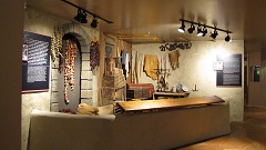
     Some of the many interesting exhibits in the Heritage Centre.


    From the viewing platform at the Heritage Centre you can look out to El Camino Real de Tierra Adentro and the Rio Grande. 

    I can’t begin to imagine what it must’ve been like for the settlers who travelled along the road with no maps, no satellite navigation, no cell ‘phones and no water expecting to be attacked by hostile Apache at any moment.   Even now with all of the above in our truck it wouldn’t be much fun to break down or be lost out here.

    Have fun, we are!

    More Ghost towns - found one, lost one

    We followed highway 51 in search of Engle (the one we found).

    Built in 1879 as a station on the Aitcheson, Topeka & Santa Fe Railroad, the town was probably named after R L Engle a railroad construction engineer.

    Engle became a thriving cattle town, at one time having a population of about 500, it was also a shipping point for supplies and ore.   When White Sands Missile Range to the east of Engle was created in 1945 it spelled the end for the town.

    A few of the original buildings still stand, along with the school house which is now a country church. 

    We followed the road south towards Cutter (the one we lost).

    Cutter once a mining boom town of 3,500, people moved away as the mines failed and today it’s a ranching area with no sign of the once thriving town.   We reached a sharp left turn which we think would’ve taken us to Spaceport America, we didn’t investigate further as at the moment it’s only open to the public on organised tours.

    Continuing straight ahead the road turned to dirt heading towards a couple of places on our ‘to visit’ list, the Yorst Trailhead, and Point of Rocks Overview http://www.nps.gov/elca/historyculture/yost-escarpment.htm on the infamous Jornado Del Muerto, a harsh, waterless section of the Camino Real de Terra Adentro.
    We hope to return and visit the overview and hike the trail earlier in the day when it’s cooler.   The Yorst trail is only 1½ miles long but as it crosses mesquite desert it is really easy to get turned around and it’s definitely not somewhere we’d want that to happen.

    Have fun, we are!

    Elephant Butte State Park

    Between 1910 and 1916 Elephant Butte Dam was built, when it was completed it was the worlds largest irrigation reservoir.

    We drove up to the Winding Roads picnic area, which was, I think, built by the Civilian Conservation Corps the picnic tables have fabulous views over the ‘Elephant’ Butte and lake.


    From there we continued on to Paseo Del Rio, also built by the Civilian Conservation Corps, where we followed the trail along the Rio Grande

    After that we strolled back past old fish ponds, which although no longer in use are still in remarkably good condition.

    There are campsites all around the lake and along the Paseo Del Rio, some are primitive and some with full hook-ups.

    Have fun, we are!