Monday 15 October 2012

Aloha!

Surf, sun, blue skies, beaches and shopping, having soooo much fun in Hawaii, will catch up eventually!
 
Have fun, we are!

Tuesday 9 October 2012

Socorro, New Mexico

As usual I’m trying to catch up as I’m way behind with the blog.   Socorro (Spanish for ‘help’, I think) is an old Spanish town and has an interesting history.

Our first stop was at the old San Miguel Mission which was established in 1598.  The mission is closed at the moment as during one of the many renovations the wrong sort of stucco was applied, water got into the adobe walls and they crumbled from the inside out.   Once the stucco was removed, the fix was to allow the adobe to dry out, this took over 12 months and then a new formulation of stucco was applied by hand.
 
Our next stop was the Visitor Centre where we picked up details of the Socorro Walking Tour, very handily we were able to leave the truck in the parking area at the rear of the building.


The Plaza
I think this is the oldest bar in town, no we didn’t go in, way too early in the day for us, besides which that would have meant me driving DB’s beloved truck up I25, yeh right, not gonna happen!  
 
This was once the Valverde Hotel.
 
I’m not sure if this neon sign still works.
 
Across from the plaza is a fragment of Jumbo, a huge steel vessel designed to contain the first nuclear explosion at the Trinity Site on 16 July 1945.   The Trinity site about 35 miles east of Socorro.
 
Jumbo was 25ft long, 12ft in diameter, weighed 214 tons and had steel walls 14 inches thick.   Although Jumbo wasn’t used in the first tests and was 800ft from ground zero, the only damage was to the steel superstructure around it that crumpled in the blast.   In later experiments the ends were blown out.
 
WWII Bataan Memorial.


We didn’t finish the walking tour because as usual we got chatting and ran out of time, but there is much more to see in Socorro and the surrounding areas, so we’ll be back. 
 
Have fun, we are!


Friday 5 October 2012

El Rancho De Las Golondrinas

The Ranch of the Swallows dates back to the early 1700’s and is fascinating.   It was the last stop before Santa Fe on the Camino Real and as such must have been a welcome sight for travellers who had just traversed the dreaded Camino Del Muerto. 

Torreon (defensive tower) at the entrance.
 
The ranch is part original, part restored and part period buildings brought in from other locations.
 
This is one of the oldest sections.   We learnt that the doorways were low, partly because people were smaller but also for defensive reasons, as if the thick outer walls were breached, the attackers had to look down as they tried to access the inner area, making it easier for those defending to fight back.
 
Another view of the inside.
 
 
Chapel of the Penitentes, unfortunately it was locked so we couldn’t go inside.

The Rio Grande runs through the property, luckily there is a bridge so we didn’t have to wade through the ford.
 

Fields are still planted with corn there is also a blacksmiths, wheelwrights, tanners, all the things you would need to keep a ranch running.

School house for the children.
 
Vineyard
This Molina (watermill) is the largest of the 4 at Las Golondrinas, the working parts were made in Buffalo, New York.   In the 1870’s it was brought over the Santa Fe trail to the town of Sapelló just north of Las Vegas, New Mexico were it was used for generations by the same family.   In the 1960’s it was purchased by Las Golondrinas, the adobe building is a replica of the original in Sapelló, the 20 ft water wheel has recently been restored and is powered by water carried by an aqueduct from the ‘cienega’ (upper spring).
 
We spent several fascinating hours visiting this historical place and although it’s on the edge of Santa Fe, it seemed a million miles away from all the hustle and bustle.
 
Have fun, we are!


We took the High Road

The High Road to Taos that is, it’s a lovely drive up into the mountains, through the forests and with lots to see on the way.

We knew the road we needed to take, but as we drove through Santa Cruz we almost missed it, good job we were in the right lane and could make the turn.   Our first stop was the Sanctuario de Chimayo.

Dirt from the Sanctuario is reputed to have healing qualities, I’m not exactly sure why or what people do with the dirt, but there is a room filled with walkers, wheelchairs, crutches etc. etc.   I don’t think it was a feast day or anything but the day we visited there were lots of people there. 

The entrance to the Sanctuario, no pictures are allowed inside.
 
A shrine within the Sanctuario.
 
Our next stop was higher up in the mountains, the village of Las Trampas which was established in 1751 by 12 families from Santa Fe led by Juan Argűello, who received a land grant from Governor Tomas Velez Cachupin.   The church of San José de Gracia is one of the best examples of surviving 18th century churches in New Mexico.

The church was locked so we weren’t able to look inside, but it’s a lovely adobe building.
 

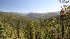
The road continued through the mountains with some lovely views across the forest, in places you could see the start of the autumn colours.
 
Taos reminded us of a miniature Santa Fe and was very busy, the main road through town was just one continuous stream of traffic, luckily we saw a parking sign, followed it, and quite nicely the parking turned out to be free.  It was a good spot, as we were close by the Kit Carson Museum and only a short walk to the plaza.
 
The museum was really interesting, although of course these days people have differing views on Kit Carson and we enjoyed our visit.
 
Taos Plaza was established in 1796 as part of a land grant to Don Fernando De Taos.   During the day it was a defensive fort and at night it was a refuge for livestock.   Today it is surrounded by stores, art galleries and restaurants.


We took a different route returning to Santa Fe, following the ‘wild and scenic’ Rio Grande for a good part of the way.
 
Have fun, we are!


Wednesday 3 October 2012

Las Vegas, New Mexico

We took I25 east around the edge of the Sangre de Christo mountains through some fabulous scenery, but unfortunately a combination of bugs on the windscreen and driving straight into the sun stopped me taking any photographs. 

Our first stop in Las Vegas, New Mexico was the visitor centre in the old train depot.   The lady there was charming and gave us lots of information about things to do and see in town as well as good restaurants and coffee shops to try.

We found a parking spot just off the plaza, in Las Vegas unless it is posted there is no time limit on street parking.   There are some lovely old buildings
 

This boarded up old building was once Navajo Textiles Inc. and during WWII was where parachutes were packed.
 
We enjoyed a milkshake and coffee inside Plaza Drug another lovely old building, this is the inside.

While I was in the visitor centre, the Plaza hotel was recommended as somewhere to be sure and visit.
 
Friendly staff actually encourage you to enjoy looking around inside the hotel, this is the main entrance.
 
During the 1800’s, I forget when exactly, this was the home of the Governor of New Mexico.
 
The grass on the plaza had only been down a month or so when we visited, it was a lovely shady place to sit and we spent some time chatting to some very nice people we met.   The parks staff were busy mowing (not something we’re used to seeing in New Mexico) and the smell of new mown grass and hot sunshine was just gorgeous.
 
The band stand.
 
This sculpture in honour of Nuestra Señora de Los Dolores to Our lady of Sorrows Parish and Mothers Against Drunk Driving was erected on 21 July 2012.
One of the recommendations for lunch was a place on the plaza that makes its own burgers and fries from scratch, Plaza Burgers, we tried it and they were delicious.
 
Sadly we ran out of day and never got to visit the railroad side of town that we’re saving for our next trip to this area.   Of course if we hadn’t spent so long chatting on the plaza……………………..
 
Have fun, we are!


Monday 1 October 2012

Bandelier National Monument, Falls Trail

From the visitor centre the Falls trail follows Frijoles Creek through the forest it’s about a 3 mile round trip.

Strange, tent like rock formations along the trail.

 
Bridges along this trail were also removed as part of the flash flood prevention last year and in most places have been replaced by planks.

Although just before we came to the wilderness sign we did come across one deep section of the creek that had no boards so we had to scramble around to find somewhere to cross and then climb up the bank before continuing on.   After doing this we came across a sign that warned about poison ivy, so then of course I spent the next couple of days hoping we didn’t come out in an itchy rash, thankfully we didn’t.
 
The trail guide warns you about steep 400ft drop offs and we wondered where they were, but once you pass the wilderness sign the path climbs high up the side of the canyon along a narrow ledge before coming down to the falls.
 
The Upper Falls.
 
The trail used to continue to the lower falls and then onto the Rio Grande, but during the floods last year this part of the trail was washed out and is no longer safe. 
 
The closed section of the trail with the Rio Grande in the distance, this section must be really bad as the signs say you can be fined and/or arrested if you try to walk it.

There are a couple of other trails we’d like to hike at Bandelier, but needless to say we ran out of time so these will have to go on our ‘to revisit’ list.
 
Have fun, we are!


Bandelier National Monument, New Mexico

Bandelier National Monument is about 48 miles northwest of Santa Fe on NM4.   Like Zion, Bryce and the Grand Canyon, Bandelier uses a shuttle service from the nearby town of White Rock, our driver was excellent and told you snippets of information along the way.   We like shuttle services although it does make deciding what you need for the day a little more difficult than when you can just pop back to the truck if you’ve forgotten something.

The main loop trail leads off from the visitor centre

in Frijoles (bean) Canyon towards the big kiva, Tyuonyi and the cliff dwellings.
 
Tyuonyi village
 
The trail climbs up to the base of the cliff

It was like climbing up into Swiss cheese, if there was a ladder you could climb up into the dwellings
 
which were surprisingly roomy inside, although I wouldn’t’ve liked to have lived in them, as they were a little claustrophobic and reminded me of the catacombs we visited in Malta.
 
Some of the dwellings.
 
There are petroglyphs all along the trail

These pictographs are behind a perspex sheet to protect them from the elements and vandals.

During the flash floods last year following the devastating Las Conchas fire the park service removed bridges to try and stop debris piling up and making the situation worse.   In places flash flood markers on the trees were about 8ft high.
 
After crossing Frijoles Creek, we followed the trail to look at Alcove House
 
I say look because it is a 140ft vertical ascent to get into Alcove House and there was absolutely no way we were going to climb up there.
 
Have fun, we are!