Saturday, 25 July 2015

Whittier, Alaska

Whittier is an unusual place as other than arriving by boat from Prince William Sound the only way to get there is to either drive or take the train through the Anton Anderson Tunnel.   Although I suppose if you really wanted to you could hike across the mountains.
 
We paid our $12.00 and got in line with the other vehicles waiting to use the tunnel, as it was early in the season we didn’t have to wait long, but I imagine the queues could be quite long during the summer.
 
As trains also use the tunnel there are huge fans and escape routes all along it’s length, about 2½ miles, each time the tunnel is used there is about a 15 minute wait to allow time for the fumes to clear.   A traffic light system advises when it’s your turn to start through.   It’s a strange feeling as you start to enter the narrow one way tunnel.
 
Driving towards the tunnel.
 
Just about to drive into the tunnel.

I did take some photographs as we drove through but none of them came out very well.   As you reach the end of the tunnel, signs point you back onto the road otherwise it’d be so very easy to carry on following the railway tracks!
 
We paid our $10.00 to park on the harbour and then looked for that most important of things on a cold, rainy day, a coffee shop!   Once we’d enjoyed hot chocolate and coffee we walked along the harbour.  Even on a mostly cloudy, rainy and chilly day the views across Prince William Sound were spectacular.

The sun peaking through on the mountains.

Whittier Harbour

We had hoped to take one of the many boat trips out into Prince William Sound, but none were available when we were there.
 
Walking around town we visited the museum, it’s small, but interesting.   The route from Prince William Sound to interior Alaska has been used for centuries, by among others, the Spanish, the explorer Valdez came this way, as did the Russians.   In 1941 during WWII, the US Army built the railway line and tunnel so that as an ice free, deep water port, Whittier could be used to bring in material and personnel to defend Alaska.
 
At the end of WWII the army port was deactivated and abandoned for a short while, before being reactivated during the Cold War.   In 1960 the port was finally deactivated.   The 1964 earthquake destroyed what remained of the waterfront and rail yard, leaving only the huge cold war buildings.   Today most of these buildings are used as homes by the majority of the residents of Whittier.
 
We had lunch at the Inn at Whittier, right on the waterfront enjoying the views across the harbour and out across Prince William Sound as we ate.
 
Full of scrumptious food we continued our walk around the harbour, where a lady I was chatting to told me that they’d had very little snow this year, but on average they get around 266 inches.   I can’t imagine what it must be like to have live somewhere that has so much snow.   There were some lovely handmade leather items in this gift shop.

These lovely wooden dolphins were on the harbour.  

Have fun, we are!

Tuesday, 14 July 2015

Exit Glacier, Seward, Alaska

 
Not far from Seward, Exit Glacier is part of the huge Harding Icefield.   A remnant of the Great Ice Age, each year between 150 and 200 inches of snow fall on the icefield.  Harding icefield covers a huge part of the Kenai Peninsula, and is 50 miles long and 30 miles wide, something that wasn’t discovered until the early 1990’s.   It’s hard to visualise that much snow and ice.
 
As yet no-one knows just how deep the icefield is, but as some of Exit Glacier’s crevasses can be more than 100 feet deep……  

At one time it was possible to walk right up to the glacier and stand under a glacial overhang, unfortunately people can and have been swept underneath never to be seen again.   Imagine disappearing underneath all that, it doesn’t bear thinking about!

These days the trail ends at an overlook to try and stop this happening. 

The view from the end of the overlook trail.

A distant view of the glacier is pretty amazing.

A round trip hike on the much more strenuous 3.9 mile Harding Icefield Trail takes you right to the edge of the glacier, climbing about 3,000 ft right to the edge of the glacier it’s about a 6 – 8 hour round trip.   Maybe, possibly, one day! 

We walked down onto the outwash plain, the views were pretty impressive, needless to say when I dipped my hand into the water it was ice-cold.

There were several inukshuks, I had a go a building one,

DB was distinctly underwhelmed by my effort, I thought it wasn’t actually bad for a first attempt. 

Looking back towards Exit Glacier and the Harding Icefield.

As we walked along the trails we kept seeing brown signs showing dates, 1815, 1914, 1951, etc. etc., and wondered what they meant.  An informational board told us that Exit Glacier has been retreating since the Little Ice Age.   The signs showed how far into the valley the glacier extended in 1815 and how far it had retreated by 2007.    

As you can see from the photographs, it was very overcast and quite cold the morning we visited, even so we had a great visit.  We got the timing right as well because later that day it absolutely poured with rain.
 
Have fun, we are!

Monday, 13 July 2015

An exciting cruise from Seward!

One of the main things we wanted to do in Seward was cruise the Kenai Fjords. We had two choices for the day we wanted to go, but only one company had a Kenai Fjords Park Ranger on board that day, so that’s the company we chose.
 
This was our view as we sailed out of the harbour.


As we sailed along the ranger pointed out a mountain goat in the shade of an alder tree on the side of a sea cliff.   I looked but all I could see was a green patch, I zoomed in and clicked and there it was.

Further along as we sailed past Bear Glacier, the ranger told us that the icebergs we could see (bottom right corner of the photograph) were probably at least 100ft high.

We cruised around these unusually shaped rocks, sadly I’ve forgotten the name of them.

The highlight of our cruise was when whales were spotted, as we saw not one but two humpback whales!
 
I just managed to catch the tail of one as it dived in the ocean before the Aialik Glacier.    It was so exciting, especially as it was only mid May and we really thought it was too early in the year to see them.

Our boat threaded its way through tiny icebergs to the foot of the Holgate Glacier where it falls into the ocean.    The Holgate Glacier is part of the huge Harding Icefield.

 
As the boat slowly approached, the chill flowing down from the glacier went right through us and despite wearing numerous layers we were absolutely frozen.

I don’t know why but I always imagined that glaciers were quiet, they’re not.   They creak and groan and rumble and squeak occassionally emitting a huge roar as a section falls into the ocean.   I was glad we weren’t any closer.

 A close up view of the top of the glacier.

It was bitterly cold out on deck, but we didn’t want to go inside, after all who knows if we’ll ever do this again.   As we turned to leave a crew member caught a ‘small’ iceberg, I don’t think I’d’ve liked to try and haul it in.

The iceberg wasn’t actually that ‘small’ when it landed on deck, a piece was chopped off and used for ice in drinks, but I have to say after all his hard work we were so cold the only thing we wanted was hot chocolate!

We’d had fabulous weather all day, but as we turned back to Seward the weather closed in, so we stayed inside, only venturing out again as we sailed past this rock.

It turned out to be a resting place for lots of seals.

As we arrived back into the harbour a sea otter cruised by nibbling on something tasty.

Our cruise was fabulous and, as it turned out, we’d picked the best day of the week for it. 

Have fun, we are!

Seward, Alaska

After our visit to the Sea Life Centre, we checked into our hotel.    Our room had gorgeous views across Resurrection Bay, after which we took a walk around Seward.

The bay is naturally ice free and in 1895 a network of trails were created to transport, men and goods to mining camps on the Turnagain Arm and Kenai River.   Eventually the trails stretched as far as Nome. 

The actual town of Seward was founded in 1903 by the Alaska Central Railway Co, as the ocean terminus of the proposed railway to interior Alaska.   After the project went bust the unfinished rail bed became part of the network of trails.  The Alaska Road Commission improved the trails and named it the Seward to Nome Mail Trail.   After the 1909 gold stampede to Iditarod the trail became known as the Iditarod Trail.

The famous 1,094 mile Iditarod Trail Dog Sled race from Anchorage to Nome was first run in 1973 and in 1978 it was designated as a National Historic Trail. 

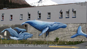
Just some of the beautiful murals we saw on our walk around town.


The coastal path has campsites along the way to the harbour, with fabulous views across the bay.  

If we were in our fifth wheel this would be a fabulous view to wake up to on a gorgeous sunny morning.   Not so sure we’d feel the quite same if it was snowing though!

Seward Harbour.

Seward is a lovely town and luckily for us the sun shone almost all the time we were there.
 
Have fun, we are!

Friday, 19 June 2015

Sea Life Centre, Seward, Alaska

Our first stop in Seward was the Alaska Sea Life Centre, where we learned that Seward was almost wiped out by a tsunami caused by the Good Friday earthquake back in 1964.   A wave estimated to be 40ft high smashed into the waterfront and destroyed railcars, fishing vessels and oil tanks, which created fires that caused even more damage.
 
It took years for the salmon to return, seafood processors and fishing vessels were destroyed, most of which were never rebuilt.   The waterfront today is home to parks, campgrounds and the Alaska Sea Life Centre.
 
Looking out at the calm waters of Resurrection Bay it seemed hard to imagine the seas raging as they did then.
 
There were some very interesting exhibits at the centre, including a area full of birds.   I liked this very pretty bird, I can’t remember what it is, but isn't it cute?
 
I know this is a puffin and think it may be a tufted puffin, but once again I didn’t write it down at the time.
 
There was also an observation area where we were able to watch seals swimming underwater.
 
As I took the photographs into the sunlight through glass it had polarizing effect.

If you’re ever in Seward the Alaska Sea Life Centre is definitely worth a visit.
 
Have fun, we are!
 

Portage Valley, Alaska

Moose Flats is the start of the Portage Valley and was our first stop, it’s also the start of the Trail of Blue Ice, a hike that takes you through the valley.  
 
Our next stop was the Express Glacier, to start with we couldn’t find it, I know, I know, how could you possibly miss a glacier.   It’s actually a ‘hanging’ glacier, hanging half way up the mountain so once we looked up there it was.

From there we drove on to Portage lake and glacier, we’d read that the Visitor Centre was worth a looking at, but it was closed when we visited. 

When gold was discovered in Turnagain Arm, the easy way to get there was from the Cook Inlet, but in the winter the inlet was clogged with ice.   So, gold seekers made their way from ships in Prince William Sound.   Between 1893 and 1903 hundreds made their way up Portage Pass a route used for centuries by the Dena’ina Athabascans, the Alutiiq and later Russian fur traders. 

Portage glacier is on the far right of the photograph.

Ropes and pulleys were used to haul their packs and sleds up the east side of the pass before they crossed the glacier.   In 1896 over 400 hundred people safely made the crossing, but in 1897 3 men lost their way in a storm.   Strong winds blew their dogs and most of their gear over a cliff and one man fell into a crevasse and disappeared into the glacier.   What a horrible way to die. 

Portage lake and glacier from a different angle.

The route across Portage glacier was used to haul mail and freight from Prince William Sound until 1903 when improvements to the trail to Seward provided an easier route. 

Chunks of ice regularly fall from the glacier and this one was floating around on our first visit.   It was actually quite blue, but that doesn’t show very well in the photograph.

Ice anyone?

We also took the short two mile round trip hike, out to Byron glacier.   Just before you get to the actual glacier there is a small wall with a sign that basically says unless you know what you’re doing on a glacier then you should stay behind the wall. 

Water running from an opening in the glacier forms a small stream littered with rocks, I dabbled my fingers in the water and it was sooooo cold it took my breath away.
As you can see there is absolutely nothing but your own common sense to stop you walking out onto the glacier as far as you like.

Beyond the wall it just looked like rocks, so we carried on.   But, just a few feet beyond the wall, we realised that while what we were standing on was rock a little further along it looked decidedly iffy.   As we know zilch about glaciers and really not fancying the idea of disappearing into the depths of the glacier never to be seen again, or maybe discovered in a few thousand years, we didn’t go any further.

It is really rather beautiful though.


Have fun, we are!