On yet another lovely morning, in our trusty Williams guide book we
found a drive that looked interesting, along the Old Peavine Railroad.
Now we know our guide book is about 15 years old, and let’s face, it all guide
books are out of date even before they’re published! But the
drive was marked as suitable for normal cars and with the exception of one hike
where we just couldn’t see the trail as it entered the forest, all the other
drives and hikes we’ve ever followed have been exactly as described.
The drive followed the old Peavine Railroad as it wound up the
side of the mesa, along the top and then back down the other side where it eventually rejoined
the paved road.
We found the road, followed it, part way along it turned to dirt,
but according to our trusty guide book it was a good dirt road. The road was okay, a little rougher than the
guide book said but we were expecting that, although I wouldn’t want to drive
it in a normal car.
After a while it became quite narrow as we were actually driving
on the old railroad bed, the road was built up on each side and every so often
we'd go through a cutting as it wound its way along slowly climbing the side of
the mesa.
Driving through a cutting
After about 9 miles, it got narrower and rougher we reached a
cattle grid by Wolf Mountain Ranch (yes that is a wolf in the photograph, but a
metal one)
leading into Prescott National Forest and onto Forest Road 573,
now maybe this should’ve given us a clue as to cross the cattle grid we had to take
down the barbed wire fence.
Still the forest road, although looking rough didn't seem too bad
I asked DB if he thought we should turn around. We thought about it but decided that as we
were about halfway through the drive we may as well carry on, so carry on we
did. What a mistake to make!
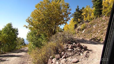
Once on FR 573 the road got much rougher, the first thing we had
to negotiate was a hill, at the top of which we met a small Toyota truck coming
the other way, luckily there was space to pass, the truck pulled in we said
hello and the truck continued on its way down to the cattle grid.
As the truck had come from the way we were heading we thought,
well it can't be that bad! How wrong can you be!
It got worse, much worse, I suppose 15 years of monsoon rains, forest fires and
snow had literally swept the road surface away and we were driving on bedrock.
The forest encroached and the road actually got narrower, I don’t
know what would’ve happened if we’d met anyone else coming the other way. It also got rougher, a lot rougher and
despite 4WD and driving at less than walking pace, we were bouncing around like
popcorn!
It definitely wasn’t suitable for a car, never mind our truck, it really
was a jeep or ATV road and we were literally climbing over
boulders! We reached another hill, stopped at the bottom, both
looked at it and said, among other things, Oh! My! God!
Our Oh! My! God! moment
It doesn’t look too bad does it? But, this is what those boulders
actually were like.
We probably could've made it but who knew what we were going to
find when we got to the top? Not only
that, but if we had to turn round, could we?
Could we get down without ripping of the exhaust or the running
boards? Besides which what would we be
driving into further along, would it be worse?
Who knew, certainly not us.
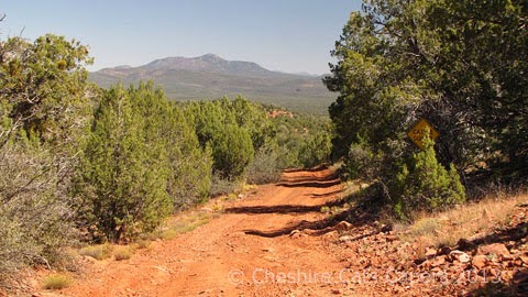
I got out and walked up, the views were fabulous, green forest on
each side of the road, red rocks, mountains in the distance, sunshine, blue
skies absolutely gorgeous but!!!
Looking at the road, knowing we’d got at least another 9 miles of who
knew what to negotiate I thought I really don't like this we're on our own out
here, probably no cell service so no rescue if anything happens. Come to that the road was so narrow how on
earth anyone would rescue us was another matter, never mind how much it would
cost and it was a very, very long walk back. Not only that but while we drive on plenty of dirt roads, this road was way out of our comfort zone, time to turn around while we still could!
Looking back down at BT.
Luckily for us, we’d stopped at a slightly wider section of the
road, albeit a very rocky section, where thankfully there was just enough room
for DB to do a 3 million point turn. I did
plenty of running round the truck giving directions every so often I’d move a
particularly vicious looking rock, well if I could, luckily for me most of the nasty
rocks were moveable, then off we’d go again.
This is where we did our 3 million point turn.
Eventually we got turned around and I hopped back in the truck. We hadn't come as far as we’d thought a mile,
mile and a half, maybe two at the most, but it had taken us ages.
This was one of the views on the way back that is Bill Williams
Mountain in the distance, isn’t it gorgeous?
We bounced our way back and we were soooo glad to see that cattle
grid and get back onto the other road I tell you it felt like driving
on the interstate after the forest road!
This is how driving through one of the old railroad cuttings
looked on our return journey. I have to
admit I didn’t realise how narrow and steep it was until I saw it from this angle.
I checked on the internet afterwards and someone else driving the
same make and model of truck as BT had tried to drive that road from the
opposite end looking for boon docking sites. They'd turned around for the same reasons we
did, so we definitely made the right decision.
Had we not, who knows we might still be out there!
Someday
I would like to see where that road goes, but only if we we’re with someone in
a jeep who knows how to drive these types roads better than we do!
Have
fun, we are!


