Friday, 4 August 2017

Ozona, Texas

Leaving Kerrville we re-joined I10 and headed west, stopping at Ozona, ‘the biggest little town in the world’ according to the sign to fill up with fuel and coffee.

Ozona is in Crockett County which was created from Bexar County in 1875 and named in honour of Davy Crockett who died at the Alamo.

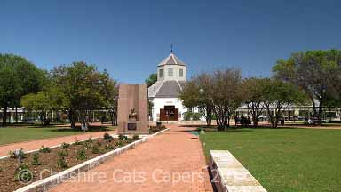
After our coffee we drove into the centre of town to have a look at the Day Crockett Memorial on the plaza.

We’d been told that Ozona Museum is well worth visiting, but unfortunately it was closed when we were there.

There are some very interesting old buildings around the plaza, one of which was the Ozona National Bank, although I don’t know if it’s still open.


There seems to be a lot of interesting history in Ozona and the surrounding areas

Have fun, we are!

Passing through Texas Hill Country

From Galveston, we, thankfully, managed to avoid the snarl up that is Houston, took the ring road around San Antonio and headed to our next stop in Kerrville, Texas.

While our hotel in Kerrville was okay, the first room we were allocated absolutely stank of smoke.   I didn’t realise hotels still had rooms that allowed smoking.   I was glad we only stayed a couple of nights as I could smell smoke the whole time we were there.

But apart from that we had a great time and found a great restaurant called Billy Gene’s overlooking the Guadalupe River.

Guadalupe River.

One of the places we re-visited was Fredericksburg, our first visit was during our first year of RVing.   It’s a nice town and is very proud of its German Heritage; the National War of the Pacific Museum is also very interesting. 

Fredericksburg.

Bandera, self-proclaimed ‘Cowboy Capital of the World’, is also somewhere we’ve visited a couple of times before, it’s a quirky, friendly place.   This trip we found a great new coffee shop.

Dog Leg Café, Bandera.


Have fun, we are!

Thursday, 3 August 2017

On to Galveston

From New Orleans we drove along bayous crossing the intra-coastal waterway several times until we reached Lake Charles.

We didn’t actually get to do much in Lake Charles as during the night we ended up under a tornado watch which was a bit scary and the next morning we were under a severe thunderstorm watch.   Somehow a trip out into the swamps and bayous to visit a nature reserve didn’t seem like a very good idea!

The next morning we left Louisiana behind as we headed for Texas and Galveston Island.   Our route took us along bayous on the edge of swamps and down to the Gulf of Mexico.
  
We stopped at a country store along the way where I learned that people thereabouts swim in the rivers.   When I asked about alligators I was told that ‘the ‘gators don’t bother ya much, leastways not where the boats usually go’!   I mean, alligators don’t bother you much! and don’t usually! go where the boats go!!!!   I think I’ll stick to swimming pools!

Following the Gulf we drove through Port Arthur, where we took the road out to the Bolivar Peninsula, before driving once more along the Gulf, where we boarded the free ferry to Galveston Island.

The Gulf of Mexico along the Bolivar Peninsula.

The free ferry to Galveston Island.

There wasn’t too much wait for the ferry on the Bolivar Peninsula, but on the Galveston side it was very busy.   Our hotel was mid-way across the island and right across from the beach where it was much quieter; we had a great view across the Gulf.

The view from our hotel.


In the harbour there were quite a few different types of oil rigs ready to put to sea, at night we could see rig lights out in the gulf, they’re drilling for oil and natural gas.

One of the rigs in the harbour.

We took a trip around the Ocean Star Drilling Rig, a decommissioned oil rig, it was really interesting.


While we were in the harbour area this lovely ship was setting sail.


One thing we discovered was that at one time Galveston was a major port of entry for immigrants from Liverpool and Western Europe, we always assumed it was Ellis Island in New York.

When we visited Moody Mansion we discovered that some of the historic houses were built from limestone and bricks used as ballast on ships from Liverpool.

Moody Mansion.


The storms were still lingering in the surrounding areas, but the weather while we were on the island was mostly lovely, although when we paddled along the beaches rough seas had washed up an odd dead fish and Portuguese Men O’War, which while they look pretty have horrible stingers even when they’ve been beached for a while.


We had a great time in Galveston.

Have fun, we are!

Wednesday, 2 August 2017

Catching up & New Orleans

Once again I’ve got way behind with the blog, no excuses as to why, just having way too much fun I guess!   So here goes with catching up.

It was late, dark and in places decidely seedy looking, as we drove to our hotel on Beinville Street in New Orleans, the next morning everything looked much better.

For our first day we’d booked a Mississippi paddleboat cruise to the Chalmette Battlefield on the Creole Queen.  Our trip was narrated by an excellent guide who was full of information, there was so much to take in that I promptly forgot most of it.

Paddle Steamer on the Mississippi

At the battlefield an NPS guide gave a short talk on the history of the battle.   Basically, in about 1815 Chalmette was the location for the Battle of New Orleans against the British.   New Orleans won, we lost that’s about all I can remember.

Gun emplacement at the Chalmette Battlefield. 

Monument at Chalmette Battlefield.

Chalmette is a huge place and we only had time to see the small section by the Visitor Centre.   It would’ve been nice to have had time to see more, but the boat doesn’t wait if you’re late. 

Looking across the Mississippi to Algiers Point.

Back on dry land we picked up our ticket for the Hop-On-Hop-Off Bus.  The bus travels a set route around different areas of the town and you can get on and off as many times are you like.   Our ticket was valid for 24 hours from the time of purchase. 

Jazz musicians on Jackson Square.

Jackson Square.

We stayed on the bus and listened to the guide as we drove all through the different districts of New Orleans. 

The Garden District.

I forget exactly when, but at some point during the day, we discovered café-au-lait and beignet!   I think absolutely scrumptious just about sums them up! 

Scrumptious beignet.

The next day we took a guided walking tour of St Louis No 1 Cemetery, one of the famous above ground cemeteries, Easy Rider was filmed there.   At one time the cemetery was in such a state of disrepair that you were likely to be mugged if you ventured inside.   These days the archdiocese only allows family members or licensed tour guides to visit, so thankfully we were dodging other tour groups rather than muggers!

St Louis No 1 Cemetery.

Although the graveyard looks small there are lots of tombs, it’s almost like a city and would be very easy to get lost; our tour guide was very informative. Among the many tombs we saw was that of Marie Laveau the notorious ‘Voodoo Queen’, legend has it that if you place your hand on her tomb and make a wish it’ll come true.   As I can’t remember what I wished for I doubt I’ll ever know! The cemetery closes at 4.00 p.m. and it’s definitely not somewhere I’d like to visit after dark! 

The tomb of Marie Laveau.

That afternoon, after more café-au-lait and beignet, they are deliciously addictive, (obviously totally calorie free, we wish!) we took another guided walking tour, this time a ghost tour.   The tour took us around the streets of the French Quarter, we heard tales of Jean Lafitte, villainous slave owners, Romeo and Juliet type lovers and haunted hotels, it was great fun, but as it was an afternoon tour it was all quite tame.

The French Quarter.

Bourbon Street.

While really enjoyed both tours, two walking tours, on what to us was a very hot and humid day was way too much, despite comfy shoes our feet were killing us and we were both absolutely shattered and yes, we did drink lots of water. 

The French Market.


There’s lots more to see in New Orleans and one day we’d like to go back. 

Have fun, we are!

Saturday, 18 March 2017

Chloride, New Mexico

Caballo Lake was overcast and cloudy as we headed off for the almost ghost town of Chloride.   Once we exited the interstate we left the cloudy skies behind.  

We’ve visited Chloride before, it’s a lovely drive with endless skies and wide open views.

At Winston we followed the road further into the mountains before coming to halt in Chloride at the parking area by the store and museum.

Once a silver mining town with mostly tough, hard working, hard drinking miners, Chloride grew to have a population of about 3,000 people.  

The town had practically everything a person could need, saloons, stores, assay office, laundry, livery stables, hotel, blacksmiths, red light district, etc., etc.,  but no church!

Freight, mail and passengers came from Engle, about 50 miles away and ox powered freight wagons drove the trails to Magdalena, making at least one trip a year to St Louis to bring in heavy freight.

Even though Chloride survived the silver panic in 1893 the town gradually dwindled away and now it’s a quiet little village backing onto the Gila National Forest and the Black Range.

We saw these deer wandering down the street as we left.

While we were in Chloride we had gorgeous blue skies and sunshine,

but as we got closer to Caballo, the darker the skies became.


Have fun, we are!

Giant Desert Figures

Giant Desert Figures.    The intriuging sign points up a gravel road leading into the desert.   Each time we’ve driven past I’ve wanted to explore, each time we’ve had the fifthwheel on the back, so not a good idea.

The Big Marias Area of Critical Environmental Concern is home to numerous rock art sites and also to geoglyphs, known as the Blythe Intaglios. 

Heading into the Big Maria Mountains.

Undiscovered until the first planes flew over the area, the age and meaning of the geoglyphs is unknown, lots of theories, but no-one actually knows. 

Similar geoglyphs exist in England, Australia, Peru and Chile but the only known ones in the US are at Blythe. 

The geoglyphs or ‘intaglios’ are created by scraping away surface gravel to reveal lighter gravel and soil underneath. 

As they’re delicate and easily damaged they are fenced, this human figure is 102ft from head to toe and its arms are almost 65ft long.

We found the other human figure, which is the longest and least disturbed, it’s just over 105ft from head to toe and it’s arms are nearly 92ft wide.  

Yes, this one is upside down, it was the only way I could photograph it without facing directly into the sun.


There are more figures including an animal one, but by then it was getting late so we never did find it.   Maybe next time. 

Have fun, we are!

Return to Oatman, AZ

Oatman was founded in 1906 and by 1931 the mines around Oatman had produced over 1.8 millions ounces of gold, the boom was over by the mid 1930’s.
Classed as non-essential to the war effort the last few mines closed in 1942. 

It’s a few years since we last visited Oatman, after finding a parking spot on Old Route 66 we strolled into town.  

The burros were out in force.   In Oatman the burros rule and traffic waits for them.   They came to town with the first prospectors and were used both in and out of the mines.  

As the mines closed the burros were released into the hills and now their descendents roam the streets of Oatman looking for handouts from the tourists.   Feeding the baby burros can kill them, so they all have stickers on their foreheads.

Hollywood movie stars Carole Lombard and Clark Gable spent their Honeymoon in the Oatman Hotel.   These days it’s no longer a hotel, but does have a restaurant and museum.


Oatman’s always busy and the day we visited was no exception.   We had a fun time, enjoyed a scrumptious ice-cream along with some people and burro watching. 

Have fun, we are!