Monday, 13 July 2015

Seward, Alaska

After our visit to the Sea Life Centre, we checked into our hotel.    Our room had gorgeous views across Resurrection Bay, after which we took a walk around Seward.

The bay is naturally ice free and in 1895 a network of trails were created to transport, men and goods to mining camps on the Turnagain Arm and Kenai River.   Eventually the trails stretched as far as Nome. 

The actual town of Seward was founded in 1903 by the Alaska Central Railway Co, as the ocean terminus of the proposed railway to interior Alaska.   After the project went bust the unfinished rail bed became part of the network of trails.  The Alaska Road Commission improved the trails and named it the Seward to Nome Mail Trail.   After the 1909 gold stampede to Iditarod the trail became known as the Iditarod Trail.

The famous 1,094 mile Iditarod Trail Dog Sled race from Anchorage to Nome was first run in 1973 and in 1978 it was designated as a National Historic Trail. 

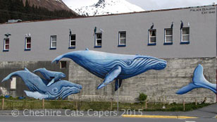
Just some of the beautiful murals we saw on our walk around town.


The coastal path has campsites along the way to the harbour, with fabulous views across the bay.  

If we were in our fifth wheel this would be a fabulous view to wake up to on a gorgeous sunny morning.   Not so sure we’d feel the quite same if it was snowing though!

Seward Harbour.

Seward is a lovely town and luckily for us the sun shone almost all the time we were there.
 
Have fun, we are!

Friday, 19 June 2015

Sea Life Centre, Seward, Alaska

Our first stop in Seward was the Alaska Sea Life Centre, where we learned that Seward was almost wiped out by a tsunami caused by the Good Friday earthquake back in 1964.   A wave estimated to be 40ft high smashed into the waterfront and destroyed railcars, fishing vessels and oil tanks, which created fires that caused even more damage.
 
It took years for the salmon to return, seafood processors and fishing vessels were destroyed, most of which were never rebuilt.   The waterfront today is home to parks, campgrounds and the Alaska Sea Life Centre.
 
Looking out at the calm waters of Resurrection Bay it seemed hard to imagine the seas raging as they did then.
 
There were some very interesting exhibits at the centre, including a area full of birds.   I liked this very pretty bird, I can’t remember what it is, but isn't it cute?
 
I know this is a puffin and think it may be a tufted puffin, but once again I didn’t write it down at the time.
 
There was also an observation area where we were able to watch seals swimming underwater.
 
As I took the photographs into the sunlight through glass it had polarizing effect.

If you’re ever in Seward the Alaska Sea Life Centre is definitely worth a visit.
 
Have fun, we are!
 

Portage Valley, Alaska

Moose Flats is the start of the Portage Valley and was our first stop, it’s also the start of the Trail of Blue Ice, a hike that takes you through the valley.  
 
Our next stop was the Express Glacier, to start with we couldn’t find it, I know, I know, how could you possibly miss a glacier.   It’s actually a ‘hanging’ glacier, hanging half way up the mountain so once we looked up there it was.

From there we drove on to Portage lake and glacier, we’d read that the Visitor Centre was worth a looking at, but it was closed when we visited. 

When gold was discovered in Turnagain Arm, the easy way to get there was from the Cook Inlet, but in the winter the inlet was clogged with ice.   So, gold seekers made their way from ships in Prince William Sound.   Between 1893 and 1903 hundreds made their way up Portage Pass a route used for centuries by the Dena’ina Athabascans, the Alutiiq and later Russian fur traders. 

Portage glacier is on the far right of the photograph.

Ropes and pulleys were used to haul their packs and sleds up the east side of the pass before they crossed the glacier.   In 1896 over 400 hundred people safely made the crossing, but in 1897 3 men lost their way in a storm.   Strong winds blew their dogs and most of their gear over a cliff and one man fell into a crevasse and disappeared into the glacier.   What a horrible way to die. 

Portage lake and glacier from a different angle.

The route across Portage glacier was used to haul mail and freight from Prince William Sound until 1903 when improvements to the trail to Seward provided an easier route. 

Chunks of ice regularly fall from the glacier and this one was floating around on our first visit.   It was actually quite blue, but that doesn’t show very well in the photograph.

Ice anyone?

We also took the short two mile round trip hike, out to Byron glacier.   Just before you get to the actual glacier there is a small wall with a sign that basically says unless you know what you’re doing on a glacier then you should stay behind the wall. 

Water running from an opening in the glacier forms a small stream littered with rocks, I dabbled my fingers in the water and it was sooooo cold it took my breath away.
As you can see there is absolutely nothing but your own common sense to stop you walking out onto the glacier as far as you like.

Beyond the wall it just looked like rocks, so we carried on.   But, just a few feet beyond the wall, we realised that while what we were standing on was rock a little further along it looked decidedly iffy.   As we know zilch about glaciers and really not fancying the idea of disappearing into the depths of the glacier never to be seen again, or maybe discovered in a few thousand years, we didn’t go any further.

It is really rather beautiful though.


Have fun, we are!

Wednesday, 27 May 2015

The Last Frontier

Alaska has been on our ‘to visit’ list for ages, and this year we finally made it!   We flew into Anchorage and started our adventure.   Our first day was cloudy, showery and windy, we felt right at home!
 
As we drove along the Seward Highway, the sky was moody, mysterious and extremely windy.   I almost got blown away when I hopped out of the car and took this photograph of the Turnagain Arm.
 
The Turnagain Arm is part of the Cook Inlet and got its name after Captain Cook had to ‘turnagain’ after failing to find his way through to Prince William Sound.
 
Our first stop was the tiny town of Hope.   Originally a tent city called Whiskey, gold was discovered here in 1888, way before Dawson and Nome and before Anchorage even existed.   Gold was plentiful and at one time there was a population of 3,000.   The gold rush soon faded and the town dwindled to only 23 people.
 
This cabin is on Main street, but I’ve no idea how old it is.

The school house was used from 1938 until 1986.

As for how it came to be called Hope, well as I understand it a new name couldn’t be decided upon, so, it was decided to name the town after the next person who got off the boat, his name was Hope.   Today Hope has a population of about 200.
 
The Good Friday earthquake of 1964 lowered the Turnagain Arm by about 6ft and that spring quite a lot of Hope flooded.   Main Street ends at what are now tidal flats.
 
This road leads down to the tidal flats.

While it looks like open ground leading to the water, it’s all privately owned and is a haven for migrating birds.

The Seaview CafĂ© was once the General Store and the bar next to it was the home of the Manager for the Alaska Commercial Company.   The building was one of several moved to higher ground after the earthquake.

It’s about 16 miles from the Seward Highway along the Hope Highway, Sixmile Creek follows the road,

before joining the Turnagain Arm, needless to say there are some fabulous views.
 
One showery evening we were in the right place at the right time and saw this beautiful double rainbow.

When it isn’t raining it looks like this.


Isn’t it absolutely gorgeous!
 
Have fun, we are!

Friday, 6 February 2015

Welcome to Mexico – Huh?!

On a warm, sunny day we set off to Patagonia to drive along Harshaw Road and through the beautiful San Raphael Valley.   I’m sure I’ve mentioned this before, but do not speed through Patagonia, you will be caught.   It is the only place we’ve ever seen huge semi-trucks slow down to the posted speed limit.
 
Needless to say our first stop was at the Gathering Grounds in Patagonia.   DB had coffee and the most enormous chocolate chip cookie, I had a chocolate, decaff mocha with a scrumptious warm cranberry and apple muffin.   Obviously it was all totally calorie and fat free!   We wish!
 
Absolutely stuffed to the gills, we hauled ourselves back into the truck and followed Harshaw Road into the mountains.   We found a lovely spot with a small stream running beside it.
 
At an elevation of 4,850ft, we stopped at Harshaw Townsite, as far as we could see this is the only building left, no idea what it was used for.

Across the road the cemetery is well looked after,

there are always flowers on the graves.
 
The dirt road continues high into the mountains, with smaller dirt roads branching off to old mining camps.    Resisting the temptation to explore, we followed the road into the San Raphael valley
 
and the tiny border town of Lochiel.

As you drive into town a huge stone cross on the roadside commemorates the arrival into what is now Arizona, on 12 April 1539 of Fray Marcos De Niza, Vice Commissary of the Franciscan Order and Delegate of the Viceroy in Mexico; he was the first European to travel west of the Rockies.  

Known as La Noria during the Spanish and Mexican eras, the tiny town was renamed Lochiel, by the Cameron Brothers who managed the San Raphael Cattle Company in the valley and were descendants of the Campbell clan of Lochiel in Scotland.  
 
As we stopped under this huge cottonwood tree, my ‘phone suddenly beeped   “Welcome to Mexico!”   We must’ve been so close to the border it was picking up Mexican cell towers.

The Little Red Adobe School House was built sometime before 1905.
 
Continuing along the dirt road we headed towards San Raphael State Park, which
as far as we know, has never actually been open to the public.   The ranch house was used in the film McLintock, John Wayne used to throw his hat on the weathervane each time he came home.
 
Oklahoma was also filmed in the valley, although DB was not all impressed when I sang to him, can’t imagine why?!
 
The monsoon rains were good this year, so there was quite a lot of water in the valley.


Another view of the valley, we had a great drive through the beautiful San Raphael Valley.
 
Have fun, we are!

Back in Tucson

Leaving Black Canyon City, we hit I17 and the nightmare traffic of Phoenix.  We thought it would be very busy, but for once, we must’ve timed it right, as we practically sailed through the city.   Loved it!   It just goes to show that you never can tell what time, is the best time to travel through Phoenix. 
 
Arriving back in Tucson we headed for an overnight stop at Lazy Days/KOA, as the next day we were booked in for Lazy Days to sort out our problem with the water heater.   As I said in an earlier post, Lazy Days soon identified the problem and installed the new switch.
 
Next, we needed to decide where we wanted to stay.   Cooler weather over the coming days made up our minds for us, we’d stay in Tucson.   After all the weather would be cold/freezing/raining/snowing/windy one or all of those things when we got home!
 
Have fun, we are!

Black Canyon City

Williams was getting chillier by day and night, so we decided it was time to move to somewhere warmer.
 
On our travels we’ve driven past the signs on I17 for Black Canyon City many times, but never stopped, this time we decided we would.   As we drove out of Williams, it was a beautiful sunny morning, but the temperature was only 47F, when we arrived at Black Canyon Ranch RV Resort a couple of hours later it was 83F.   So we went from heaters to air con in a couple of hours!
 
Our site at Black Canyon Ranch RV Resort, it would be a bit tight pulling in if the park was full.   Once we’d finished setting up I headed for the pool and hot tub, it was ages since we’d been anywhere I could swim so that was lovely. 

A little while later I took a walk around the park, it’s a nice place, very well maintained and everyone seemed very friendly. 

Driving under I17 we found The Squaw Peak Coffee Shop, where we stopped and enjoyed coffee with a brownie for DB and a warm croissant for me, delicious!

Afterwards we drove back through Black Canyon City and on into Rock Springs where we topped up the diesel.   As well as the gas station, there’s an art studio, a farmers market, and the Rock Springs CafĂ©.

There is even a ‘spoof’ Rock Springs cemetery, with some quirky ‘grave stones’.

I particularly liked this one about ‘Cowboy Joe’.

The Farmers market had some lovely salsas and preserves, not to mention garden fresh tomatoes, why do we always find these places near to the end of our trip?
 
It’s a nice area and there’re things we’d like to go back and see, so I think we’ll be back.
 
Have fun, we are!