Thursday, 12 November 2015

San Juan Bautista State Park

On the day we visited volunteers were dressed in period costume as part of a living history day at the San Juan Bautista State Park.  
 
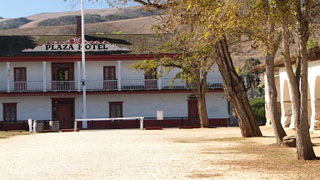
Originally, what is now the Plaza Hotel, was a one-story adobe barracks and two-story guard house for the soldiers protecting the mission.   In 1835 the building became a home and general store for the Anzar family.
 
It was then sold to an Italian immigrant, Angelo Zanetta who added the second story and opened the Plaza Hotel in 1859.   The hotel became famous for its excellent cuisine and liquors.
 
By the 1860’s San Juan Bautista was a stop for 7 stagecoach lines and when the Idria Quicksilver mine opened south east of town, even more people stopped at the hotel.

A reconstruction of what the dining room would’ve been like, you could get ham and eggs for 40c and a coffee for 10c.

If you were a traveller in the mid 1800’s it would take you about 58 hours to travel the 366 miles from LA to San Juan Bautista, at an average speed of 6.8 miles an hour and cost $20.00. 

Well furnished rooms were available to travellers, but single travellers shared a room and sometimes total strangers shared a bed!   Not something that would ever even be considered now, thank goodness.

The Castro/Breen adobe is an example of eastern and western building methods produced in Montery and formed the Monterey Colonial Architectural style.
 
The adobe served as headquarters and residence of José Antonio Castro, Commandant General of Alta California and later as home to  Donner Party survivors Patrick Breen and family.

One of the demonstrations was cooking in a ‘horno’’ oven, it took 3 hours for the horno to get hot enough to put food in.   Thank goodness for microwaves, I’m really glad I don’t have to cook like that every day!

Across the road at the rear of the stables,

a blacksmith was demonstrating his work.

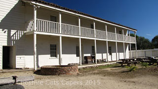
Unmarried mission women once lived in a dormitory on this site, in 1835 the enlarged building became the headquarters for General Jose Castro’s cavalrymen.  

The building was later purchased by hotel owner Angelo Zanetta and used to store hay.   He and his partner hoped to sell the building as the San Benito County Courthouse, the ground floor contained offices and the first floor was one long open room. 

After Hollister became the county seat, Zanetta added a dining room and kitchen for his family home and the upstairs was used for town meetings and balls.  

Just across the road from the plaza hotel is a small settlers cabin and what was possibly the first log cabin in California.   It was moved from its original location on Mission Ventura Ranch.

Once we’d finished looking round the state park, we walked through town,

we had coffee and lovely apple cinnamon turnovers in the bakery

I loved this handbag in one of the store windows.

San Jaun Bautista is a lovely little town and we really enjoyed our visit. 

Have fun, we are!

Mission San Juan Bautista, California

Mission San Jaun Bautista is the oldest building in San Benito County and  was founded on 24 June 1797 by Father Lasuen, it is the 15th of the 21 California Missions.   It is also the largest and only church that has 3 aisles.   A monastery wing with 36 rooms was dedicated in 1812.
 
The mission has never been abandoned and is now the parish church of San Juan Bautista, it’s a lovely building.
 
Entry to the mission is through the gift shop, but we arrived before it opened and so we took a walk around the outside.
 
In 1957 the Mission and Plaza were used by Alfred Hitchcock during the filming of ‘Vertigo’, Kim Novak jumped from the bell tower in the film.

A nearby marker shows the route of the original El Camino Real, the ‘Kings Highway’ that connected the 21 California Missions, the road was in use from 1797 to about 1850.

Parts of El Camino Real became stagecoach routes and highways, at the start of the 20th century women’s clubs started to mark the old route with reproduction mission bells.   In fact, I think there’s a bell near highway 101 just outside our RV park.
 
Now this is seriously scary marker, somewhere you really don’t want to be when the ‘big one’ strikes California, as this is the San Andreas Fault marker.
 
Although scientists think that the next ‘big one’ is more likely to be caused by the Calaveras Fault, running through downtown Hollister 10 miles away and the Hayward Fault, not exactly sure where that is.  But even so…………

Once the gift shop opened, we paid the small entry fee and walked through into a shaded walkway. 

This tallow cauldron from 1830 is among some of the artefacts on one side of the courtyard.

On the other side of the courtyard, is a garden with benches and some gorgeous roses,

including this gorgeously perfumed one.

Inside the church, the original fonts are still in use.

The mission church.

Mission San Juan was very interesting and is definitely worth a visit, we had a great time.

Have fun, we are!

Monday, 9 November 2015

Last Day in Yosemite

On our last day in Yosemite we once again stopped at Tunnel View and took, yet more photographs.   Thank goodness for digital cameras!   The sun was a little hazy and I thought there wasn’t quite as much snow as the previous day.
 
We parked by Curry Camp and walked through the trees to the Merced River and Happy Isles. Although the Nature Centre was closed for the season, we enjoyed the short stroll along the river.  It was quite cool in the shade.

A view of Half Dome from the river.

On the way back to the truck we walked through the canvas tent cabins of Curry Village.   Some of them have heating and facilities, some of them don’t.   If you’re brave enough, or daft enough, to stay in one of the unheated canvas tent cabins overnight in the winter I found a deal on the website whereby you pay only what the temperature was the night before.   So, if it’s 15 degrees, you only pay $15.00.
 
DB, the guy who hogs the heater and really feels the cold, thought this was quite a good idea, my answer?  Not a chance!

Once back at the truck we drove over to have a look at the Ahwahnee Hotel, much more my style, it’s a beautiful place and is on the National Historic Register.   The Ahwahnee opened in 1927 and has counted Royalty, Presidents and celebrities among its guests.

I believe you can book a guided tour, but we just looked around the ground floor public spaces. 

From there we drove to a lovely meadow and ate lunch, it was a little chilly so we decided to stay in the truck.

As we ate, a huge raven perched on the car next to us casting it’s beady eyes in our direction.  Deciding it didn’t like being ignored, it landed on the bonnet of the truck, peering in before we shooed it away.   Pesky thing, I really don’t like birds! 

Our next stop was El Capitan picnic area, we thought we might get some good views across the valley.   As we walked along I saw two healthy looking ‘dogs’ sauntering along towards a family eating lunch.   As they were shooed away, a second glance made me realise they were coyotes, I’ve never seen such healthy looking coyotes.  They moved away from the family and settled underneath a nearby picnic table, along with a couple of ravens.

It’s no wonder there are signs everywhere telling you never to leave your food unattended, you never know what’s going to come creeping out of the undergrowth! 

As we drove out of the valley we stopped for one last photograph.

Despite losing a couple of days to bad weather, we really enjoyed our trip to Yosemite. 

Have fun, we are!

Yosemite National Park – Yosemite Valley

The day after we drove Tioga Pass Road to Tenaya Lake a winter storm blew in from Alaska and dropped 18 inches of snow on the High Sierra closing the road for the season.
 
Down in Coarsegold we got a day of quite heavy rain, so our campsite changed from this.
 
To this!   California is suffering from an extreme drought and is desperate for rain so everyone was very happy about this.   As for us, well it was just like being at home!

Once the storm cleared, we headed back to Yosemite and on our way stopped at Wawona General Store for some hot chocolate.   Nearby is the gorgeous Wawona Hotel, it reminds me of the one in Dirty Dancing.   As you can see I took this before the storm.

Driving into Yosemite Valley we stopped at Tunnel View and were treated to gorgeous views of snow covered El Capitan and Half Dome.

Down in the valley we found a car park and set off to walk to the Visitor Centre, where we watched one of the informational films.   Once that was over, and I have to it wasn’t the best park film ever we’ve seen, we followed the trail to Yosemite Falls. 

Yosemite Falls is one of the worlds tallest waterfalls, dropping 2,425 ft into the valley. 

Upper Yosemite Falls.
 
Lower Yosemite Falls.

Upper and Lower Yosemite Falls

A marker commemorates the fact that in 1869 John Muir built a sugar pine cabin here and made it his home for two years. 

Our last stop for the day was Bridalveil Falls.   The Ahwahneechee called the area ‘Pohono’ or ‘Spirit of the Puffing Wind’.   The falls drop 620 feet into the valley and the wind sometimes pulls the water away from th cliff making it sway from side to side.
 
Often at this time of the year there is very little water flowing over the cliffs, but with all the rain and snow the day before it was flowing well when we got there.
 
Have fun, we are!

Yosemite National Park – Tioga Pass Road

Tioga Pass Road closes for the winter after the first significant snow fall, so as the weather was still good that was where we headed for next.
 
We drove down into and out of Yosemite Valley, up onto Crane Flats and took a right heading up into the High Sierra.  
 
The road winds through pine forest and past the Tuolumne Sequoia Grove, our first stop was the beautiful Siesta Lake.
 
As we drove higher the scenery changed as we came into rocky granite sections, it was so blindingly white for a moment we thought it was snow.

I’m not sure you can see it in the photograph but whatever was used to build the road sparkled as though some had salted the road with diamonds.

The amazing rocks around Tenaya Lake.   Created as the glaciers receded over 10,000 years ago, Tenaya Lake is about 100ft deep.   Each spring snow melt travels down Tenaya Canyon and into Mirror Lake in Yosemite Valley.

There is a short hike of a couple of miles or so that takes you right around the lake.

The white stumps in the lake are dead lodgepole pines that are still rooted in the lake bottom, in anything from 20 to over 60 ft of water.   Lodgepole pines don’t live in water, so the theory is that these trees grew during a very long dry period over 900 years ago when the lake was much lower.
 
Although it’s a gorgeous white sand beach, the water was ice cold when I dipped my fingers in.

After eating lunch at the lake we decided to retrace our steps, stopping at Olmstead Point on the way.
 
Olmstead Point is named after landscape artist Frederick Law Olmstead and his son Frederick Jr.   He was chairman of the first commission to manage Yosemite Valley and the Mariposa Sequoia Grove.   It is also a starting point for wilderness hikes, one of which is the 9.6 mile Snow Creek Trail that leads into  Yosemite Valley.   Definitely a hike not for those of a nervous disposition or anyone ill prepared. 

Olmstead Point with Half Dome in the distance.

A close up view of Half Dome from Olmstead Point.

Have fun, we are!

Yosemite Park – Glacier Point Road

On our first couple of visits to Yosemite the weather was gorgeous, but the forecast was for a winter storm that would drop substantial snow and rain, depending on your elevation.
 
With this in mind we decided our first trip would be along Glacier Point Road.   It’s a lovely drive through the forest and even though we went on a weekend it wasn’t too busy.
 
On the drive we stopped beside this beautiful meadow, it’s closed for restoration and the fence is there to try and keep people out.
 
The first viewpoint we stopped at had breathtaking views.   The falls in the photograph are the Nevada (594 ft high) and Vernal Falls (317 ft high) both are on the Merced River.   Neither falls existed until after the Ice Age and a million years ago were buried under 1000 ft of ice.   Not exactly sure how anyone know it was 1000 ft, as I’m  sure no-one was around to measure it.

Although it’s possible to hike to both, hiking to the top of Nevada falls is much more difficult than hiking to Vernal falls.   We could see quite a few people at the top of Vernal Falls, but no-one at the top of Nevada Falls.
 
Glacier Point is at the top of the South Wall of Yosemite Valley and at one time had two hotels, McCauleys Mountain House (1872–1969) and The Glacier Point Hotel (1917-1969).   Both hotels were built from trees cut down near the point and both hotels burned to the ground on the evening of 9 July 1969.   The NPS decided not to rebuild the hotels, a couple of photographs from the informational board.

Half Dome and Tenaya Canyon.   Tenaya Canyon is a very dangerous place and people can and do lose their lives trying to hike through as a short cut into Yosemite Valley.

Yosemite Falls and Yosemite Valley.

This photograph was on an informational board, I can honestly say I wasn’t even vaguely tempted to try that!   Neither was anyone else, at least not on the day we were there.

Looking across Half Dome and Nevada Falls into the High Sierra and Clark Mountain Range.   The Clark range was named after Galen Clark Yosemite’s first guardian.

Have fun, we are!