Tuesday, 30 August 2011

La Sal Mountain Loop

The La Sal Mountain loop trail leaves Moab on Highway 28 and follows the Colorado River.
There are numerous campsites along the road as well as rafting put in spots, it’s a beautiful drive.

We stopped at Rocky Rapid just in time to see rafts and canoes battling their way through the waves.


Beautiful as it is I passed on paddling in the water which seemed like a good idea!
The loop trail turns into Castle Valley Road which is home the Priest and Nuns Rocks and Castle Rock (the tall spire), the valley has appeared in countless movies.   At any minute I expected to see Indiana Jones pursued by all sorts of nefarious folk zooming along!

Castle Rock was used in a car advert a few years ago when a car was perched right on the top.

The road follows the valley for a while before taking a right and climbing high into the mountains, the views are tremendous.

At the top of the mountain we found a spot with great views back to Castle Valley and beyond.

It was much cooler on top of the mountain than it was back in Moab.

Have fun, we are!

Saturday, 27 August 2011

Rock Art Trail

The Moab Rock Art Trail takes you to easily accessible rock art in and around Moab unfortunately some of it has been defaced by mindless vandals.
 
We didn’t follow the trail exactly as shown in the trail map, but the way it suited us, so our first stop was on the Potash Road along the Colorado River.

The panel had a really interesting petroglyph that is thought to show hunters and a bear.

Further along is Jug Handle Arch, where there are more petroglyphs but try as we might, we just couldn’t see them.

Moonflower Canyon along Kane Creek Road was our next stop, isn’t that just a wonderful name?   The information board mentioned a large triangular shape with headdress known as the Barrier Canyon Style figure and I think this is it.

Further along Kane Creek Road the pavement ends and the road turns to gravel, the petroglyph boulder we were looking for isn’t marked and was just down the hill on the side of the road.   Parking is just a couple of small pull ins we missed them on the way up and found them on the way back. 

The boulder (marked with the red arrow above) has petroglyphs on all 4 sides, one of which is very unusual and is known as the birthing petroglyph for obvious reasons.

The last place we stopped on the trail was the Golf course, some the petroglyphs here were really snazzy.

I’ve never seen any quite like these before they look as though they were off for a night on the town back in the disco era.

We had a great day.

Have fun, we are!

Tuesday, 23 August 2011

Looking for Goblins!

We followed the map, entered the destination in the sat nav and arrived at a gate to a dirt road, heading straight across the desert, where a sign advised “high clearance vehicles recommended beyond this point”.   Huh?  According to both the map and sat nav this was highway 303 the road to Goblin Valley State Park?   I don’t think so!
 
Continuing further along highway 24, we eventually came to a sign for the state park sending us along Temple Mountain Road, we followed the sign, took a left and we were there.   The ranger advised us that some sat navs did try to send people across the dirt road.

Goblin Valley was discovered by cowboys searching for cattle in the 1920’s and was once a tidal flat on the edge of an ancient inland sea it became an official Utah state park in 1964.  

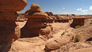
Walking through the rock formations is both weird and amazing; this one reminds me of Brian the snail from the Magic Roundabout.

We couldn’t see any flying saucers but thought this one looked remarkably like an alien.

This one looked like goblins were having a party.

It’s a very strange place to walk through and I imagine would be quite spooky at dawn or dusk.

We never did find highway 303.

Have fun, we are!

Sunday, 21 August 2011

The Burr Trail

The Burr Trail Scenic Backway retraces the path taken by John Atlantic Burr a rancher for whom the road is named.   The trail heads southeast for 66 miles from Boulder and ends near Ticaboo and the Bullfrog Marina on Lake Powell.   With the exception of about 20 miles the trail is paved all the way.

At the start of the trail we drove through some striking white rocks, we didn’t have a trail guide so I’ve no idea what sort of rock it is.

A creek followed the trail for a while before swinging away and disappearing further into the white rocks.

As the trail meandered along the white rocks turned to red, some sort of sandstone I think,

before winding its way down into Long Canyon.   Sunlight turned the rocks in Long Canyon a beautiful deep red as we drove through, following the trail as it climbed slowly through the length of the canyon.

As the truck was perched right on the side of the road, high above the canyon this has to be the quickest photograph I've ever taken, and yes that really was the edge!

Even though it’s paved the trail is recommended as a dry weather route, I can see why as sand covered parts of the trail where recent rains had washed down the canyon sides.

At the end of Long Canyon we had a fabulous view over multi-coloured rocks far into the distance.

Looking down it appeared that a camel was hiding among the rocks.

Our plans this particular day included returning over Boulder Mountain so at this particular point we turned around and retraced our route.


Have fun, we are!

Torrey, Utah

Torrey, Utah is a small town at the junction of highways 24 and 12.   The town was settled in 1898 and named for Colonel Jay L Torrey of the 2nd regiment, a volunteer cavalry known as the “Rocky Mountain Riders”.

Torrey is also home to a log church and schoolhouse building made of sawn logs, the building is architecturally significant as one of the few remaining Church of the Latter Day Saints meeting houses built during the initial settlement phase. It is also the only known example of a log meeting house still standing in Utah.

The building was restored by the Daughters of the Utah Pioneers and is still used for religious and social functions. 

Our campsite, Thousand Lakes RV Park, http://thousandlakesrvpark.com had beautiful views of red rocks in one direction;

in the other, Boulder Mountain and the Aquarius Plateau.

It’s a lovely campsite, with fabulous dark skies at night we’ll definitely stay there again.

Have fun, we are!

Friday, 19 August 2011

Capitol Reef National Park

Capitol Reef is home to the Waterpocket Fold a hundred mile long warp in the earth’s crust and is just amazing. 

We listened to the ranger talk about the petroglyphs created by the Freemont People, named so by archeaologists after the Freemont River which runs through the park.  Anthropomorphs feature quite prominently in these petroglyphs; some are really obvious while others are barely discernible.

The historic district of Fruita has acres of orchards producing all sorts of different fruit including peaches and apples, the park service maintains the orchards and for a nominal fee you can pick your own fruit.  Or better still, buy a homemade fruit pie from the Gifford House they are truly delish!

We hiked up to Hickman Bridge; it’s only a short trail quite steep in sections but only about a mile each way.  It climbs up from Highway 24 crosses over a fairly level section before diving down into a wash and then climbing up to the bridge.   It was a very hot morning, but despite the heat it was well worth the effort.
Late one afternoon we watched a thunderstorm as it rumbled its way across the mesa behind Chimney Rock, the lightening was spectacular.

Ripple marks left in the rock from when the area was a humid sub- tropical land of tidal mudflats, hard to imagine when you see look around now.

The scenic drive through the park was undergoing some repair work so was only open as far as Grand Wash, guess we’ll have to come back someday and see the rest.

As you enter Grand Wash a sign warns you not to enter if storms are threatening and I can see why, you literally are driving through a wash and wouldn’t have much of a chance if you were caught in a flash flood, it was pretty spectacular though.

Cassidy Arch

Have fun, we are!

Wednesday, 17 August 2011

Ridin' the hogsback!

Scenic Highway 12 travels from Highway 89 just outside Panguitch across to Torrey on highway 24 it is one heck of a drive, but parts of it are definitely not for those of a nervous disposition!

John Wesley Powell and his expedition came this way and from Henrieville to Head of Rocks east of Escalante highway 12 follows their exact route.

On one section of the road the remains of an Ancestral Puebloan Granary can be seen tucked into an alcove high above.

Past Escalante the road gets, interesting, this is the view from Head of Rocks, yes, there is a road down there.

From here the road dives down into Escalante Canyon before making its way up to the hogsback.

Yes, we really did meet a fifth wheel coming down the hogsback, it’s actually the second one we met, I was so surprised I didn’t even think to photograph the first one.

The hogsback is a very narrow strip of road there is practically no shoulder on either side, in fact the upright post in the photograph below is the end of the road!
Highway 12 continues down into the small town of Boulder on a road built by the Civilian Conservation Corps, they started work in 1935, it took, them 5 years and tons of dynamite to complete the road.

Before that the only way to get to Boulder was either by wagon through Escalante canyons, or during the summer over Hell’s Backbone a dirt road created by the Civilian Conservation Corps in 1933.

From Boulder highway 12 climbs up through quaking aspens travelling over Boulder Mountain.

This section of the road was only opened as recently as 1985, before that the only way over the mountain was an unpaved road that was impassable during the winter.

Highway 12 goes from desert to alpine in a matter of miles and has great views across the surrounding areas, it’s a great drive, but I don’t think we’ll ever take the Cougar that way!

Have fun, we are!

Monday, 15 August 2011

Kodachrome Basin State Park

Kodachrome Basin State Park is 9 miles from Cannonville on highway 12 along a paved road following the Paria river.

Because of the colourful rocks in the area it was named Kodachrome Flats (with permission from Kodak)  by a 1949 National Geographic expedition.   It is simply gorgeous.

Our first stop was Chimney Rock.

After that we headed off to Shakespeare Arch, I’m not at all sure why it’s called Shakespeare Arch after all it’s an awful long way from Stratford-upon-Avon.   The trail to the arch is easy after that it’s marked as strenuous.

One of the gorgeous views from along the trail.

Our next stop was the Angels Palace Trail, it’s about 1½ miles long and climbs about 150ft above the basin floor.   The trail starts from the parking area near the campground, crossing the road and heading up a narrow red rock canyon, in places the following a dry wash.

Before climbing round the side of the canyon to the top, yes that really is the trail in the photograph below. 

From there we followed the cairns and markers across the slickrock in a loop and were treated to some amazing views.


Now this section was a little close to the edge for me!

After all that hard work we stopped by the store and thoroughly enjoyed an ice-cream on the porch.  


Have fun, we are!