Wednesday, 27 July 2011

Cedar Breaks National Monument

The Southern Paiute called the place u-mapwich – “the place where the rocks are sliding down all the time.”

Later settlers renamed it Cedar Breaks:   Cedar for the cedar or juniper trees growing nearby, and “Breaks” a term for badlands in 1933 Cedar Breaks National Monument was established.

 The scenery is spectacular.

A lot of snow falls here in the winter, last winter the only thing that could be seen of the historic visitor centre was the top of the chimney.

We took the short hike from Chessman Ridge Overlook down to the Alpine Pond, although there was still snow in a couple of places, wildflowers filled the forest and crowded over the path.

Pretty as it was we didn’t linger long by the pond as the mosquitos were biting.  Ouch!
 Wildflowers along the trail

As we were hiking we’d seen black clouds starting to form as we got back to the truck thunder started to rumble around us, so our return was well timed.

Have fun, we are!

Butch Cassidy Lived Here!

Truly, Butch Cassidy really did live here.

It’s not marked but 25 miles north of Panguitch (pronounced Pangwitch) on highway 89 is Butch Cassidy’s old homestead, we only recognised it from the photograph in the Bryce Country guide.

Panguitch is also the place where Butch last met his mother at the Blue Pine Motel, which is also still there.

Have fun, we are!

Pioneer Days

The weekend of July 24 is Pioneer Days in Utah and commemorates the arrival of Mormon Pioneers into what is now Utah, when Brigham Young said ‘This is the Place’.

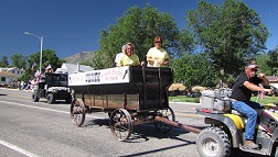
Although we were travelling as we approached Marysvale on highway 89 the Sherriff was stopping traffic so we were lucky enough to watch the Marysvale parade.

The parade was led by Veterans, who as always received a big cheer.

There were lots of other floats, from the Fire Department,

Ranches,

Businesses,

Carnival queens who’d all mastered that ‘royal’ wave beautifully.

The girls on this float were having a great time boogying along to Abba and Dancing Queen.

Not to mention the rodeo queens.

All too soon it was over and the Sherriff waved us on our way.

Have fun, we are!

Sevier River Trail

A paved biking/hiking trail follows the Sevier river along an old railroad grade from Sevier Junction through Marysvale Canyon.

We joined the trail near the old Eagle Rock tunnel, because of falling rock inside the tunnel and the cost of making it safe, not to mention losing its historic value the trail goes round the tunnel rather than through it.

Although it climbs steadily it’s an easy trail

with nice views across the canyon and of the fast flowing river.

white water rafters floated past on their way to the take out spot further down

The day we hiked fire teams were busy damping down the remains of a brush fire on both sides of the river, thankfully they’d managed to catch it before it did too much damage.

Have fun, we are!

Big Rock Candy Mountain

“Oh the buzzin' of the bees in the peppermints trees near the soda water fountain,
At the lemonade springs where the bluebird sings on the Big Rock Candy Mountains”
 
I remember the song by Burl Ives from when I was a kid, (DB claims never to have heard of it) well near Marysvale on highway 89 we found Big Rock Candy Mountain, although I believe the mountain wasn’t given the name until after the song was first recorded in 1928 by Harry McClintock.

 Today there is a resort at the bottom of the hills and it’s on part of the Paiute ATV trail.

Although I looked very carefully I couldn’t find either the peppermint trees, soda water fountain or the lemonade springs, mind you the coffee from the resort was good and hot!

Have fun, we are!

Monday, 25 July 2011

Freemont Indian State Park

A thousand years ago, Clear Creek Canyon was home to the largest community of Fremont Indians ever discovered.  
 
Around 1400 A.D the trail through Clear Creek Canyon was used by the Paiute Indians to travel between hunting grounds in the Pahvant and Tusher mountains.

During one trip a new born baby died.   All winter the mother worried about the baby being alone in the cold lonely place, so the following spring she returned and painted a blanket on a nearby rock so that the baby could use it during the long cold winters.

Now the blanket is visible high above I70 and can be from highway 4 the park road.

Later on explorers travelled the same route eventually the trail was improved and became a wagon road in 1872.   For the next 25 years it would cost 25 cents for each wagon to use it.   Homesteaders arrived, a school was built and in the 1890’s gold was discovered nearby at Kimberley this made Clear Creek Canyon an important route to the railroad at Sevier.
 
During construction of I70 in the 1980’s most of the canyons inhabitants left and on Five Finger Ridge, a Freemont Indian Village was discovered. 
 
Thousands of artefacts were excavated and are now on display in the museum.

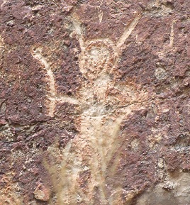
Trails lead to interesting rock art on both sides of I70.   This one is thought to indicate good hunting in both directions.

Not sure what this one means, but it kinda looks like an alien to me.


Have fun, we are!

Escape from the City

As nice as it is, Salt Lake City is a city, so on a lovely sunny morning with thankfully not a thunderstorm in site, we escaped!
  
Our destination was Richfield, a small town in central Utah with a very nice KOA.

Have fun, we are!

Friday, 22 July 2011

Mormon Tabernacle Choir

We took the shuttle from Salt Lake City KOA to see the Mormon Tabernacle Choir as they performed their 4,270th live broadcast.

The choir usually perform in the Tabernacle, however due to increased visitor numbers during the summer and in December the live broadcasts take place in the conference centre which holds 21,000 people.  There were 5,000 people on the day we were there.

Both the choir and the symphony orchestra are comprised of volunteers. To join the choir you have to pass an audition, if accepted you then spend some time in the choir training school joining the choir when a place becomes available.   Members can remain with the choir for 20 years or until they reach a certain age, which I think was 60.

They are extremely good and we really enjoyed the performance.

Have fun, we are!

Tuesday, 19 July 2011

Playing in the snow!

Utah had a very heavy snow pack last winter and as we drove to Salt Lake City the high peaks of the Wasatch Mountains glistened white in the sunshine, before the thunderstorm that is.

Our trip up Little Cottonwood Canyon ended at Snowbird, where we took the tram to the top of Hidden Peak at 11,000 feet.

The views from the summit were spectacular.

All the  summit trails were closed because of the snow.

A couple of passengers on the tram had their skis and were skiing/hiking down.
Looked like fun, but we stuck with the tram.

Have fun, we are!

Antelope Island State Park

A causeway connects Antelope Island State Park situated in the Great Salt Lake to the mainland.   The Great Salt Lake is a remnant of the huge Lake Bonneville that once covered over 20,000 square miles.

Although water flows into the lake there is no outlet so evaporation leaves a high concentration of minerals.   The water is saltier than the ocean and only brine shrimp, brine flies and several types of algae can survive in the lake.
 
The island is also home to bison, pronghorn antelope, mule deer, big horn sheep, coyote and over 250 species of bird not to mention being on a migration route for 4 to 6 million birds who feed and nest on the Great Salt Lake each year.

This pronghorn antelope (?) was enjoying the grass on the side of the road leading to the historic Fielding Garr ranch.
 
The Fielding Garr ranch house which was built in 1848 is the oldest Anglo built house still on its original foundation in Utah.

The bison were about a ½ mile away from the ranch so my photograph is not very clear.

We stopped at Bridger Bay, it’s very pretty and plenty of people were enjoying the waters, I fully intended to join them, but the brine flies at the edge of the water freaked me out, so maybe another time.


Have fun, we are!

Salt Lake City, Utah

Negotiating a thunderstorm, rain and road works, we exited I15 north and arrived at the KOA in Salt Lake City.   Thankfully the thunderstorm had disappeared over the horizon by the time we’d checked in and found our site.

Salt Lake City KOA is right in the city and members of Jesus Christ of the Latter Day Saints provide a free shuttle to take you to Temple Square we took advantage of this the next day.   Missionaries greet you on arrival and take you on a half hour tour after that you are free to look around at your leisure.

Temple Square is a very impressive place with not a leaf out of place.   We were told that there are over 250,000 plants in the gardens which are maintained mostly by volunteers.

At the weekends wedding parties pose in front of the fountains and the Temple.

With the exception of the Temple itself, visitors are free to enter all the buildings.   We were in the Tabernacle when the acoustic test was carried out and you really can hear a pin drop.

A guide took us up to the 26thfloor of the Church Administration Building where there are fantastic views over Salt Lake City.

 
We hadn’t intended to visit the Family History Building and had taken absolutely no information with us, so someone suggested we start off in the Joseph Smith Building, they were very helpful and sent us over to the Family History Building, where, considering what we started out with we found out quite a lot.   DB is now hooked and going to pursue this further.

The foyer of the Joseph Smith Building which is home to the Navoo Café where we had a very nice lunch.
Have fun, we are!

Monday, 18 July 2011

Cove Fort

Brigham Young asked Ira Hinckley to build a fort at Cove Creek, a days ride from both St George and Fillmore.   The intention of the fort was to protect travellers from Indians and as a refuge on the long journey.   The fort was built in 7 months and was never needed as protection.

Once the railroad came through fort was no longer needed and was sold over the years became it dilapidated and was on the verge of falling down until the Hinckley family bought and restored it.  The fort is now owned by the Church of Jesus Christ of the Latter Day Saints and missionaries are happy to show visitors around.

Inside the Fort.
One of the bedrooms inside the Fort, the rolling pin on the headboard is to roll the mattress when it gets lumpy, if you happened to have a husband who snores I can think of other uses for that rolling pin!

The dining area, visitors and family all ate together and when Mrs Hinkley prepared meals, she baked huge loaves in 5lb tins.

Cove Fort is between just off both I70 and I15.

Have fun, we are!

Old Fort Deseret

Old Fort Deseret was erected in 18 days by 98 men in 1865 as a defense against Pahvant Indians during the Blackhawk War.   It would be pretty good going these days to build a fort like this so quickly!

The fort was built of adobe made with mud and straw mixed by the feet of oxen, it was 550 feet square, the walls were 10ft high, 3ft thick at the bottom and 1½ ft thick at the top.

There were huge gates in each side with bastions at the northeast and southwest corners, the whole rested on a stone foundation.

Today all that remains are the adobe walls on the side of the road.

Have fun, we are!

Territorial Statehouse, Fillmore, UT

In 1851 Brigham Young, as Governor of Utah Territory designated Fillmore, named after President Millard Fillmore and the geographical centre of Utah as the location for the Territorial Capitol. 

Grand plans for a capitol building were drawn up and the building commenced but only the south wing of the building was ever completed.

The Legislature sat in Fillmore just a couple of times before voting to make Salt Lake City the capitol, probably the difficulty in getting to Fillmore through the winter snows helped make that decision.

Brigham Young took a corner room in the building for his office because of the light, although his clerks probably spent more time in the room than he did.

The Legislature room was on the top floor.

Fillmore was laid out in the same plan as Salt Lake City, the streets are 132 feet wide, this was to enable a team of oxen to turn around in one go.   It’s a nice little town and has no stop lights!

We stayed at the KOA which has very helpful friendly owners and lovely views of the mountains it is also right on the Paiute ATV trail while we don’t have an ATV it is a very pretty spot.   I got lucky and took this photograph before everyone else rolled in.


Have fun, we are!